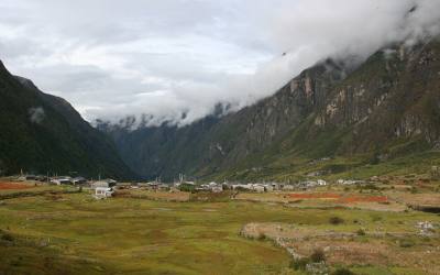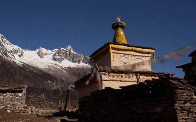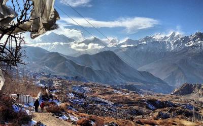
Around Manasulu
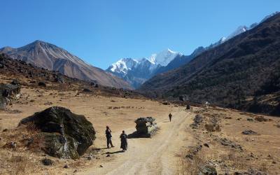
The Manasulu circuit is one of the best remote trekking area in Nepal. The most prominent of the peaks are Baudha himal, Gorkha Himal and Himal Chuli. the area is bordered by two major river systems .to the east Budhi Gandaki and to the west Marshandi Khola . most attraction of this treks are the views of the Manaslu range and the Annapuna ranges and the forest and bird life along the ridge. The course starts from Gorkha. The ancestral seat of the reigning Shah dynasty, and the temple of Manakamana, one of the most popular pilgrimage sites for Hindu devotees. The route follows the rugged gorge of the Budhi Gandaki river through wild Gurung country. As the land rises the people change to more Tibetan-influenced Bhotia, and the first of many extensive mani walls appears before crossing the Larkya pass. It is one of the easier high passes in Nepal. But heavy snow can make the route difficult especially on the western side where deep snow drifts are likely to be found.
Flora and fauna
The range of geographical and climatic regions has led to a diverse variety of flora and fauna with in this region. these parts of area are heavily cultivated and the landscape is terraced paddy fields for most of the year.the higher up in the hills the natural vegetation changes from the tropical species to more temperate stands of forest trees including oak, beech and rhododendron. There is not a large variety of animals will be spotted although barking deer and Himalayan marmots may be spotted above the tree line. Pheasants may be seen in the jungles just below the tree line and all of the usual alpine birds including ravens, coughs and various birds of prey.
People and culture
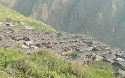
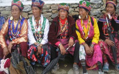
The most prominent ethnic groups in this region are the Gurung, Braman, chetri, Manangba, Tamang and Tibetan. Above the tree line near Larke Pass, people of Tibetan origin inhabit several villages. A number of large Buddhist monasteries are to be seen in the upper reaches of the Budhi Gandaki.
Part of Annapurna Circuit
Annapurna area is the most popular trekking region in Nepal, every year visited by 70 percent of trekkers, and for good reason. the deep valleys and high mountains encircling the giant Annapurna himal embrace a wide range of peoples and terrains, from subtropical jungle to a geographic extension of high, dry , Tibetan Plateau. The scenery is superb mix of lush vegetation, mountain peaks and an endlessly changing procession of people.
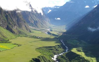
The course is called the Marshyandi trail. It goes upstream along the Marshyandi river. Trek through canyons and gorges and move on the north side of Himalayas pass Manang. Which was once kingdom.Cross Palace, people that live in the villages on this route are the Brahman, Cheetris, Newars, Tamangs, Gurungs and brought about by Hinduism and Tibetan Buddhism.you will also see the climatic and environmental distinctiveness of the both in the south and the north of the Himalayas.
The course is called the Marshyandi trail. It goes upstream along the Marshyandi river. Trek through canyons and gorges and move on the north side of Himalayas pass Manang. Which was once kingdom.Cross Palace, people that live in the villages on this route are the Brahman, Cheetris, Newars, Tamangs, Gurungs and brought about by Hinduism and Tibetan Buddhism.you will also see the climatic and environmental distinctiveness of the both in the south and the north of the Himalayas.
Flora and Fauna
As can be imagined, the range of geographical and climatic regions has led to a diverse variety of flora and fauna within the Annapurna region. Both Pokhara and Besishahar are below 1000 meter elevation and their climate is quiet tropical. These parts of area are heavily cultivated and the landscape, therefore, largely consists of terraced paddy fields for most of the year. The area is also famous for its winter crops of oranges, which can be purchased fresh from the trees along the trails in the foothills. As you progress higher up into the hills the natural vegetation changes from the tropical species to more temperate stands of forest trees including oak, beech and rhododendron. These finally give way to coniferous forests of pine and, ultimately, juniper just below the tree line. In the rain shadow, to the north of the mountains, the landscape is quite barren being an extension south of the Tibetan plateau. Here there are only stunted bushes and shrubs except for close to the rivers where irrigated cropping is possible.
Native animals to be seen include many birds the most obvious being the pika, blue sheep and Himalayan Tahr.
People and culture
The most prominent ethnic groups in the Annapurna region are the Gurung, the Thakali and the Manangba. The Gurungs are the most widely distributed being found from the hills of Gorkha district to as far west as Palpa. There heartland, however, is centered on the hills and valleys between the Marsyandi river and the kali Gandaki. The Thakali come from the upper kali Gandaki valley around Jomsom where their traditional farming has being supplemented by trade and, in particular, hotel and restaurant businesses. The Manangba are found in the upper reaches of the Marsyandi River and are in many ways similar to the Gurungs to whom they are possibly related. They are skilled traders and trace their roots back to Tibet. Religiously, the Manangba and the Gurungs of the upper hills is Buddhist with traces of their ancient, shamanistic faith still apparent. The communities live further south are predominantly Hindu.
All of the communities, particularly the Gurungs are famed for their cultural performances, which are easily seen while trekking in the region. Many villages along the trails will arrange performances for trekkers during the main seasons.
Trekking styles:
Most of the trekking routes in the Annapurna region are well serviced by teahouses for most of their length. This is particularly true for most popular treks-the Jomsom trek, the Annapurna circuit and Annapurna base camp treks.
Trekkers should be aware, however that there is always the risk of being stranded by bad weather or injury/sickness between teahouses, particularly in the more remote parts of the trek itineraries. a good example is on the Annapurna circuit where there is one very long day when the high pass of Thorong La has to be crossed. There is little or no shelter available for most of this day and some trekkers have been caught unprepared by bad weather and altitude problems.
The treks in less developed areas, particularly the Dhaulagiri circuit and the trek east of Lamjung, definitely require trekkers to be self sufficient in food and shelter.
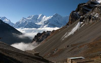
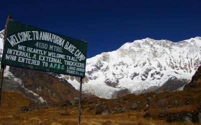
The classic trek in the Annapurna region is the Annapurna circuit. The complete circuit has only been possible since mid 1980’s when the Manang area was officially opened up to non-Nepali visitors. For and all-round experience of the scenery and culture of Nepal this trek has a lot to offer. Starting in the lush Marsyandi valley, that separates the Annapurna range from that of Manaslu, the scenery is composed of lush cultivated fields with dense forests on either side. In the winter season, orange tree are laden with fruits and fragrant frangipani blossoms cast their scent along the trails. As you travel higher the valley becomes more rugged until the villages and forests finally give way to the arid hills of Manang. The Thorong La pass, at 5416 meters, marks the highpoint of the treks after which the trail joins the kali Gandaki river that flows through the deepest gorge on earth.
This is a challenging trek that is not without some risks. The crossing of Thorong La can be dangerous at times, especially during unexpected snowfall so potential trekkers must make sure that they are well prepared and equipped for all eventualities. The trek can be completed in a minimum of fifteen days, starting in Kathmandu and finishing in Pokhara. If a few extra days are allowed for it is then possible to enjoy several of the possible side trips and add immeasurably to the experience. And entry permit for the Annapurna conservation area project (ACAP) is needed for this trek.
The first few days of the trek follow the Marshyangdi through scattered farming communities by a mixer predominantly composed of Gurungs but with a sizeable numbers of Brahmin communities. The crop range from rice and wheat at the lower elevations to corn, millet and barley as the altitude increases. Above the valley floor the hills are cloaked in forest with the occasional clearing indicating human settlements. Higher still, the snowy peak of the Annapurna and the Manaslu ranges dominate the skyline. A feature of this section of the trek is the number of high waterfalls that cascade down into the main river. The valley rises slowly slow altitude sickness is rarely a problem at this stage.
After a four days on the trail the river, which has been flowing from the north changes its course and flows from the west. At this point the landscape changes with steep rocky gorges on its side and large stands of pine making up the forest cover. By the time the district headquarters of Chame has been passed the hills are becoming more and more barren and the people predominantly Manangba. Look for a number of ancient temples, some of which represent the pre-Buddhist, Bon religion.
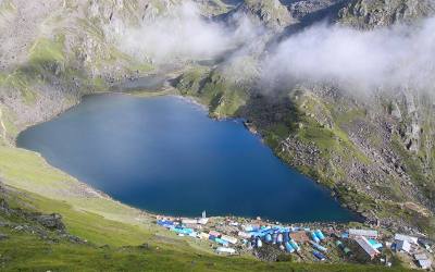
The tree line is reached a few hours before arriving at mustang where a compulsory rest day should be taken for acclimatization to the increasing altitude. There are a number of possible side trips from Manang that can be taken on the acclimatization day. Perhaps the most spectacular is to the west, across the river and up to the Gangapurna glacier with its deep blue lake formed by the melting glacial ice. The Himalayan rescue association clinic is located in Manang village and holds afternoon awareness lectures for trekkers warning of the dangers of AMS. These lectures are well worth attending.
From Manang, the trial passes through high alpine pastures until the small cluster of teahouses at Thorong Phedi id reached. An early morning start from here will allow you to reach Thorong La by mid morning and then start the long descent across the scree slopes to Muktinath before the afternoon cloud sweeps in. the whole section have no permanent settlements and shelter is hard to find. For safety, trekkers should never travel alone this section.
Muktinath, a famed pilgrimage site for both Buddhists and Hindus, is the first major settlement reached after the crossing of Thorong La. Be sure to visit the temples here and especially look for the eternal flame, fuelled by natural gas, which can be found in the small Buddhist temple below the main shrine.
From Muktinath the views of the west are now of the Dhaulagiri range while to the north can be seen the arid hills of upper mustang. The trial Leeds down through villages inhabited by people of Tibetan stock until it reaches the banks of the kali Gandaki River, the home of Thakali people. A further four days trekking down through this, the deepest valley on earth, brings you to the road head at Beni from where buses to Pokhara can be found. Settlements of particular interest below Muktinath are Jomsom with its airport, a possible exit point to Pokhara,
Day 01 : Arrival and Transfer to Hotel in Kathmandu.
Day 02: Free day in Kathmandu or self visiting around kathmandu valley
Day 03: Kathmandu to Arughat Bazar (870m)by local bus . the drive will take approximately 7-8 hours .
Day 04: Arughat Bazar to Soti Khola (700m) 4-5 hour of walking
Day 05: Soti khola to Machha Khola (869m) 5-6 hour of walking
Day 06: Machha Khola to Jagat (1340m) 6- 7 hour of walking (Resticated area start for trekking)
Day 07: Jagat to Nyak Phedi ( 1760m) 6-7 hour of walking
Day 08: Nyak Phedi to Bi Phedi ( 1990m) 5 hour of walking
Day 09: Bi Phedi to Namrung ( 2630m) 6 hour of walking
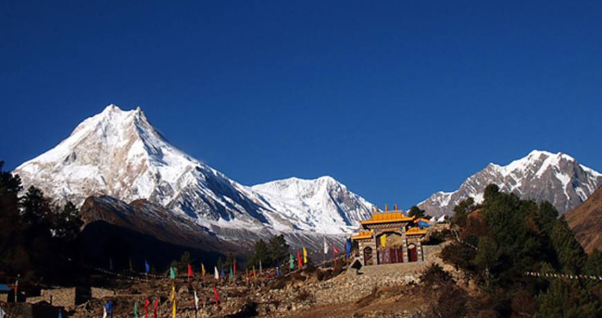
Day 10: Namrung to Sama Goau ( 3520m) 6 to 7 hour of walking
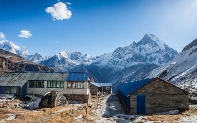
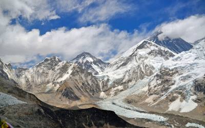
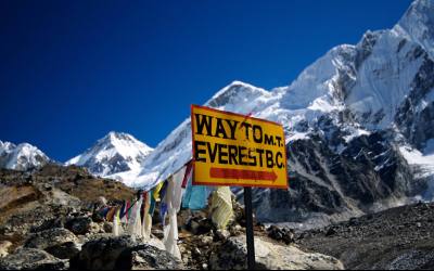
Day 11: Sama Goau to Manasulu base camp (4400m) at the evening return back to Sama Goau. The trip will take 8-9 hour of walking
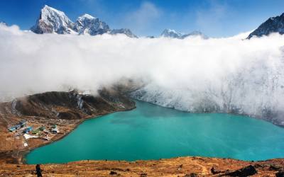
Day 12: Sama Goau to Samdo (3790m) 3 hour of walking. At the afternoon side trip to local village.
Day 13: Side trip to Ruila ( To Tibet border) and return back to Samdo.8-9hrs of trek
Day 14: Samdo to Larke Bazaar ( 4460m) 4 hour of walking. It is good day for acclimatization before crossing Larke pass
Day 15: Larke Bazaar to Larke pass (5160m) than to Bhimthang (3590m) 8-9 hour of walking ( rusticated area End)
Day 16: Bhimathang to Dharapani (1860m) 8-9 hour of walking
Day 17: Dharapani to Chame (2713m) 6-7 hour of walking
Day 18: Chame to upper Pisang (3292m) 5-6 hour of walking
Day 19: Pisang to Manang ( 3351m) 6-7 hour of walking
Day 20: Manang Rest day (3351m) and side trip to ice lake or to Buddhist Monastery
Day 21: Trek to Yak Kharka (4200m) 3-4 hour of walking
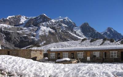
Day 22: Trek to Thorong Phedi High camp (4780m) 4 hour of walking
Day 23: Trek to Thorong la pass ( 5416m) then to Muktinath (3802m) 7-8 hour of walking than by sharing jeep to Jomsom (2730m) .
Day 24: Early flight to Pokhara (827m) and afternoon self visiting around
Day 25: Free day in Pokhara and self visiting around pokhara Valley
Day 26: Pokhara to Kathmandu by Tourist bus. the bus journey will take 7-8 hours
Day 27: Tour Ends (Departure )
Day 01 : Arrival and Transfer to Hotel in Kathmandu (1340m) Upon arrival in Kathmandu, you are met at the airport and transferred to your hotel. Our airport representative will be waiting for you in the arrival hall, located after passing out of the customs area. Look out for your name in play card outside of arrival hall. The drive from the airport to the hotel is around 20 minutes.
Day02: Free day in Kathmandu or self sightseeing around Kathmandu valley (option are)
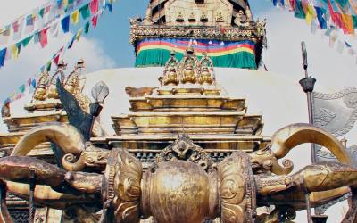
Boudhanath stupa (Buddhist Temple) is the largest stupa in Nepal and the holiest Tibetan Buddhist temple outside Tibet . It is the center of Tibetan culture in Kathmandu and rich in Buddhist symbolism. The stupa is located in the town of Boudha , on the eastern outskirts of Kathmandu .
History
Bodnath was probably built in the 14th century after the Mughal invasions;various interesting legends are told regarding the reasons for its construction. After the arrival of thousands of Tibetans following the 1959 Chinese invasion, the temple has become one of the most important centers of Tibetan Buddhism. Today it remains an important place of pilgrimage and meditation for Tibetan Buddhists and local Nepalis, as well as a popular tourist site.
Pashupatinath Temple (Hindu Temple)
Situated 5km east of kathamandu, the temple of Lord Shiva , Pashupatinath, with two tired golden roof and silver door is considered one of the holiest for Hindus. Although only Hindus are allowed inside the temple, visitors can clearly see the temple and the activites performed in the Temple premises from the eastern bank of the Bagmati river. The Temple was listed in the UNESCO world heritage Monument List in 1979.
Swoyambunath Temple( Monkey temple)
The famous Swayambunath Temple is perched on a hill outside Kathmandu and has a square golden stupa rising from a lovely white dome. Monkeys play on the steps up to this temple. Swayambhunath is said to be more than 2000 years old and is a very holy place for Buddhists as well as Hindus. You have a wonderful view over Kathmandu from here
Day 03:Kathmandu to Arughat bazar (870m) by local bus. the bus journey will take 6 -7 hours. The road till Dhading has a asphalt. The unsealed road from Dhading to Arughat bazaar is sometimes impassable after heavy monsoon rain. In this case it takes 3 to 4 hours of walking.Arughat Bazar is small market town which lies next to Buri Gandaki river. This village is a strategic point of the road from Trisuli bazaar to Gorkha and than to Pokhara. It is the largest village in the Buri Gandaki gandaki basin and there are many stores .
Day 04: Arughat to Soti Khola (790m) 4-5 hours of walking
The path will go along the Buri Gandaki all the way to its headwaters. The trail goes across forests populated by monkeys. When you reach wide area of rice paddies you will come to Arkhet. From here trail descend to a high cascading waterfall to kyorpani. This is a small village where there is Magar and Gurung people are living. From here, trail descends to Soti Khola. There is a good swimming hole and a small water fall just above the trail.
Day 05: Soti khola to Machha Khola (869m) 5 hour of walking
From here, the course will repeat ascents and descents to Almara, a village on the flank .move on , traversing the forest area. Continue a steep ascent on the rocky path , you will come across a stream. The trail eventually makes its way down and past a few rice terraces, then up to the Gurung village of Lapubesi.
Day 06: Machha Khola to Jagat (1340m) 6-7 hour of walking (Resticated area start)
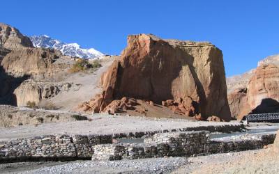
From here , traverse the slope that has farm fields and rice paddies .further ahead the valley will become a wider. There is views of Sringi Himal also called Chamar ( 7187m) . The path will will go down to the shores of white sand .trail still descends and ascents to mountain flank. After short decent you will reach to Kani Goan. It is one of the big village . soon after passing the village and crossing the Machha Khola and Namyung Khola you will reach to Kholabesi. Pass the village and the valley , follow the narrow path soon you will reach to Taopani. where it has a hot spring.
Day 07: Jagat to Nyak Phedi (1760m) 6-7 hour of walking
Crossing the suspension bridge and passing through forested area. following the path looks like it is carved in the rock to reach to Doban. Soon after crossing villages and suspension bridge in Doban khola, trail repeating ascents and descents will come to Jagat. It has a beautiful flagstone .
Day 08: Nyak Phedi to Bi Phedi (1990m) 5-6 hour of walking
Climbing over a rocky ridge of Salleri , there are a good views of Sringi Himal. Passing through the Gurung villages to reach to Ekle bhati. Where it has strong influence of Tibetan.
Day 09: Bi Phedi to Namrung ( 2630m) 6-7 hour of walking
Leaving the village and make a small ascending traverse.the path will go down to river shores. Pass the Gata khola village and Shar khola .finally it offering a pleasant walk through bamboo forests to the Deng Khola. You will reach to Deng.. at the tiny village of Deng you enter to Nepri. This part of Nepri is known as Kutsang. It is small village of Gurung and it has a strong Tibetain influence.
The path will go down to river shores. Steep cliffs continue to surround the valley. Crossing a suspension bridge to reach to Lana. The path will becomes a gentle ascent till Bih. From here on, traverse through the forest to come to farm fields and go through the khani then you are in Ghap.
Moving on to the forest and crossing a few times wooden bridge over in Buri Gandaki the path will becomes steeper till Namru village. At this stage the Tibetan border is only a few kilometers to the north.
Day 10: Namrung to Sama Goau (3520 ) 6-7 hour of walking
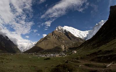
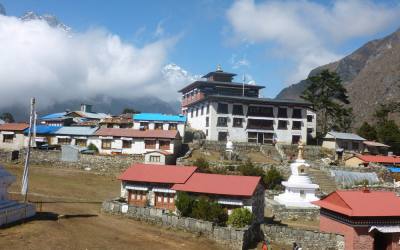
After passing through Bengsam village, LI and Khani you will come to Hinan khola. Crosses the streams, you will come to Sho village. From where the views are open Naike peak, Manaslu north peak and Manaslu. Lho has wide farm fields on the gentle mountain flank, it is a large village with many houses and a fine Gimpa. The view from here are excellent.
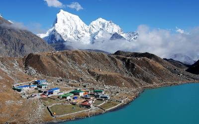
Soon after the junction, you will cross the stream using the wooden bridge and zigzag up the forested area to reach to Honsanho Gompa. Where it has an open view. After crossing Pungen glacier valley will become a wider. Move on from one Chorten to another to reach sama. Which is surrounded by a large number of Mani stones and Chortens. The Gompa on the top of the hill is very fine and worth visiting.
Day11: Sama Gompa to Manasulu base camp and return back to Sama Gompa
After Breakfast take a side trip to base camp and at the evening return back to same lodge.
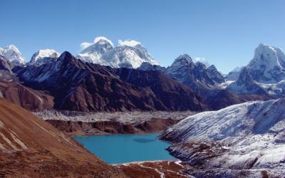
Day 12: Sama Goau to Samdo (3790m) 3 hour of walking at the afternoon side trip to local village.
Passing by the foot of the great, white slide that is the Manaslu Glacier we pass the trail that branches off to Manaslu Base Camp. Our path enters a woodland where we might see marmots in the birch and juniper bushes, before a final steep ascent brings us to the charming village of Samdo. The village has a well-established Tibetan refugee community –with Tibet being only a morning’s walk away.
Day13: Samdo to Tibet Border ( Rui-la 5000m) and at the evening return back to Samdo.
Walking north from Samdo and crossing the Athahra Saya Khola . The trail climbs gradually along the Athahra Saya Khola, then descends gently towards the river bed crossing a side river on a wooden bridge. It then climbs again and goes beside the river on its western side. After 3 hours walk from Samdo the Athahra Saya Khola turns west. On this point there is a small wooden bridge and on the other side of it a clear slope that leads to a distant mountain pass. Cross the bridge and begin to climb on the slope. At its bottom, the trail may seem unclear as there are several Yak trails going up, but as you climb it is clear that your way is… up… The climb to the top of the Rui La pass, at 4998, takes another 2 hours. Along the way there are beautiful sights of Manaslu in the distance, as well as the Hindu and Fukang glaciers just behind you as you climb. The Rui La pass is a "classic” "U” shaped mountain pass. Prayer flags mark the pass and a border stone marks the border between Nepal and "Dzong Who” – China. Numerous mountain ranges can be seen on the Tibetan side, and if you are patient enough, wait to see a Yak caravan crossing the pass to bring goods into Nepal.
Day14: Samdo to Larke Bazaar (4460m) 4 hour of walking. it is good day for acclimatization before crossing Larke pass.
After an easy first part today we cross the Budhi Gandaki for a final time before the trail gradually rises through juniper and tundra with a viewpoint overlooking the Larkya La glacier. Climbing further we arrive at the Spartan Larkya Rest House.
Day 15: Rest house –Larke pass to Bhimathang (4066m) 7-8 hour of walking
An early morning start is needed for what is to be a particularly tough and extended day. A pre-dawn start to avoid gale force wind which usually gains in strength after mid-day at the pass.
After a long gradual climb alongside a moraine we make a short descent to a glacial lake and reach the head of the moraine (4,700m) which we cross to climb to the ridge top. Four frozen lakes lie below and then it is up to the crest of the Larkya La (5,100m).
The reward for these difficult trekking conditions is brilliant westerly views of Himlung Himal, Kangurru and Annapurna II as well as the looming omnipresence of Manaslu.
On the steep descent we drop around 600m in less than an hour. Our trail then levels off onto yak pastures before finally reaching Bimtang, a collection of typical summer kharkas.
Day 16: Bhimthang to Tilje ( 1963m) to Dharapani(1860m) 8-9 hour of walking
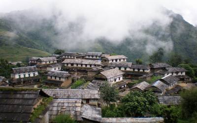
We descend on easier terrain through meadows and pine and rhododendron forest, until arriving in Hampuk. Then the path drops further, following the course of the Dudh Khola, crossing the stream fed by the snows of the Kichke Himal and arrive at Karche and then onto the village of Gho – where rice is back on the menu and Nepalese ‘dhal bhat’ is revisited. Keeping to the west bank of the river, the afternoon is one of gradual descent to the Gurung settlement of Tilije which is famous for its apple brandy
Trail decent in forested area to Hampuk , passing the kharaka, crossing the Surki khola you will start to seeing farm fields. Continue to follow path of forest on the right side of Dudha khola to reach to Tilije village. From here trail decends to Thonje. Cross the Marshandi river to reach to village of Dharapani.
Day 17: Dharapani to Chame(2713m) 6-7 hour of walking
Entering a Dence forest, cross over the bridge over tributaries and shortly afterwards near the foot of the water fall , climb steep stone steps . just beyond these up to Chame in about three and haif hour. Good views of Annapurna. The lower part of the Chame is the administrative centre of Manang district. The upper part mainly inhabited by Tibetans. There is a hot spring just below this upper section.
Day 18: Chame to Pisang(3292m) 5-6 hour of walking
Leave the upper village of Chame on the left flank follow the path in the pine forest and climb along the river repeating ascents and descents till Bharatang. From here crossing suspension bridge you will reach Manang valley. A speculates Rockwell is in view for much of this climb. It will take about 3hrs to reach pisang.
Day 19: Pisang to Manang(3351m) 6-7 hour of walking
During today’s journey, you can enjoy a wonderful view of Annapurna Himal. It is the viewing day on the Marshyangdi trail till Hongde. Which has an airfield. The road leading to Manang becomes wider. Houses are built crowded together and a white Gompa stands above them all, contrasting with the dark walls of the houses. You will see Manang on the terrace in front of you . from here enjoy the view of Gangapurna to the right of the glacier and Annapurna to left.
Day 20: Manang- Rest day ( Acclimatisation day) side trip to Ice lake or to Buddhist Monastery
This is very important day to use acclimatization before you got to high altitude. There are plenty of good day hikes in this area.
It is a proper Bhot valley. It lies in the confluence of river Marsyangdi and Thorang khola. On both side of valley-north and south –high Himalayan ranges are stretched continuosly from east to west of Manang Bhot. It falls in the rain shadow area of Annapurna range, where less than 300mm of annual rainfall occurs, most of which falls in the form of snow. This bhot balley is regarded as the coldest snow desert of Nepal.
Day 21: Manang to Yak Kharka(4200m) 3-4 hour of walking
Walking through the dark colored houses of Manang and following the path of stone walls and sandy path. You will arrive to Yak Kharka or Koche village. Koche is famous for grazing animals. In the pasture land grasses and varieties of seasonal flowers are found. It has glaciers and other water resources. It makes this place very attractive.
Day 22: Yak Kharka to Throng Phedi high camp (4780m) 4 hour of walking
Trail continues towards to remote throng phedi , you will not see anymore trees around here. Latter gradually climb uphill towards to base camp. Thorung phedi is a small hamlet situated near the Marshandi river. It is situated at an altitude of 4450m. just below the settlement, there is a big pasture land. All the other surroundings area are naked and snowy mountains.
Day 23: Thorong phedi (Thorong La 5416m) to Muktinath 3802m. 7-8 hour of walking than by local sharing jeep to Jomsom (2730m)
Today is most difficult day and highlight section of this course. It is going to be long journey and it is wise to leave early in the morning . trail continues uphill all the way to Thorong pass where you can see stone hillock with flapping prayer flag . as soon as crossing throng La trail descending all the way to Muktinath. The green, sacred land for Hindus and Buddhist.
Day 24: Jomsom to Pokhara by air(870m)( the flight will take 25 minutes)
Pokhara is set in a lovely valley at the foot of the Machapuchare so you get spectacular views of the mountains from all parts of the town. It is quite different from Kathmandu, with few temples, but it does have plenty of scenic attractions and is close to the mountains. There are some interesting short walks or bicycle rides from Pokhara, you can swim and canoe on Lake Phewa or just watch the last rays of the sun stream across the dip in the mountains that hold the lake. Along the lakeside road there is a continuous stretch of small hotels, restaurants and shops; it’s an area which still has a bit of the old hippy scene feel about it.
Day 25: Free day in Pokhara or self visiting around Pokhara valley (option are)
Pokhara is a place of remarkable natural beauty. Situated at an altitude of 827m from sea level and 200km west of the Kathmandu Valley, Pokhara city is the most popular tourist destination in Nepal. This enchanting city, with a population of around 95,000, has several beautiful lakes and offers stunning panaromic views of the Himalayan peaks. The serenity of lakes and the magnificence of the Himalayas rising behind them create an ambience of peace and magic. Pokhara city is also the starting point for many popular treks in Nepal.
Pokhara is part of a once vibrant trade route extending between India and Tibet. To this day, mule trains can be seen camped on the outskirts of the town, bringing goods to trade from remote regions of the Himalaya. This is the land of Magars and Gurungs, hardworking farmers and valorous warriors who have earned worldwide fame as Gurkha soldiers. The Thakalis, another important ethnic group here, are known for their entrepreneurship.
The climate of Pokhara is slightly warmer than Kathmandu with daytime temperatures of around 15 degrees Celsius in the winter and 35 degrees in the summer.
Sarangkot
The view of the Annapurna Himalaya from Sarangkot is almost a religious experience. From here, you can see a panoramic sweep of Himalayan peaks, from Dhaulagiri (8167m) in the west to the perfect pyramid that is Machhapuchhare (6997m) and the rounded peak of Annapurna II (7937m) in the east. Most people come here at dawn or dusk, when the sun picks out the peaks in brilliant colours.
Fewa lake, the second largest lake in the Kingdom, is the center of attraction in Pokhara. It is the largest and most enchanting of the three lakes that add to the resplendence of Pokhara.
Mahendra cave
Another of nature’s wonders in Pokhara is the Mahendra Gupha. This large limestone cave is locally known as the House of Bats, an apt name for it. A two-hour walk to the north of Pokhara, it is best to bring your own torch to see the stalactites and stalagmites, as well as the local winged residents.
Seti River
Another of Pokhara’s natural wonders that unfailingly interests visitors is the Seti river. Flowing right through the city, this river runs completely underground at places. Amazingly, at certain points the river appears hardly two meters wide. But its depth is over 20 meters! Mahendra Pul, a small bridge near the old Mission Hospital, provides a perfect view of the rivers’s dreadful rush and the deep gorge made by its powerful flow.
Barahi Temple
The Barahi temple is the most important monument in Pokhara. Built almost in the center of Phewa Lake, this two-storied pagoda is dedicated to the boar manifestation of Ajima, the protectress deity representing the female force Shakti. Devotees can be seen, especially on Saturdays, carrying male animals and fowl across the lake to be sacrificed to the deity.
Museum
The Pokhara Museum, located between the bus stop and Mahendra Pul, reflects the ethnic mosaic of western Nepal. The lifestyles and history of ethnic groups such as the Gurung, Thakali and the Tharu are attractively displayed through models, photographs and artifacts. One major attraction is a display highlighting the newly-discovered remains of an 8000-year-old settlement in Mustang.
Day26: Return back to Kathmandu by tourist bus. The bus journey will take 6 -7 hrs.
Day27: Tour Ends (Departure )
Price Per Person US$ 1375.00 (Price are based on standard class hotel)
Price for meals and drinks during the trek Allow US$ 23-25 per person per day for trekking (off-course you are going to pay every day directly by yourself to the tea houses during the trek.it is just a guideline)
Single supplement US$ 150.00 per person ( you will get single room in kathmandu and during the trek. you can also book your trekking tour as a single with us. in this case we will charge little higher)
Additional night in kathmandu will cost US$ 40.00 for Double room with Bed and Breakfast and US$ 35.00 for single room.
Trekking prices with out hotel in kathmandu will cost US$ 1275.00 per person.
Off-course it is always possible to upgrade the hotel in kathmandu according to your budget and interest. But it will cost you extra and you need to pay the differences.
Hotel we use in this tour
Kathmandu Prince Hotel (standard class hotel)
E-Mail : [email protected] Website : www.kathmanduprincehotel.com
Or
Potala Guest House (Standard class hotel)
Website : www.potalaguesthouse.com
Or
Hotel Marsyandi Mandala (Standard class hotel)
http://www.marsyangdimandala.com
Hotel we use in Pokhara
Hotel Kantipur ( 2 Star)
http://hotelkantipur.com
Delux class hotel
Hotel Manasulu (3star)
Website: www.hotelmanaslu.com
Grand Hotel Kathmandu (4star)
Email: [email protected]
http://www.grandhotelnepal.com
Hotel Manang Pvt. Ltd (3star)
Thamel, Kathmandu, Nepal
http://www.hotelmanang.com
Hotel Yellow pagoda (4 star)
Kantipath, Kathmandu, Nepal
[email protected]
www.yellowpagoda.com
Radission hotel kathmandu (5star)
https://www.radisson.com/kathmandu-hotel-np/nepkathm
Hotel Yak & Yeti (5star)
Durbar Marg, Kathmandu, Nepal
http://www.yakandyeti.com/
Hotel Barahi (Delux hotel 3 star)
Lakeside,Pokhara-6,
http://www.barahi.com
Hotel Temple tree resort and spa (Delux hotel in Pokhara) 4 star
Gaurighat, Lakeside 6, Nepal
http://templetreenepal.com
Fishtail Lodge Pokhara (5star)
P.O. Box 10
Lakeside, Pokhara, Nepal
E-mail:
[email protected] / [email protected]
http://fishtail-lodge.com/fishtail/
shangri-La Kathmandu & Pokhara (5star)
Address: Lazimpat, Kathmandu Nepal
Email: [email protected]
Shangri-La Pokhara:
Address: Gharipatan, Pokhara, Nepal
http://hotelshangrila.com/
Note: As per our company rule to confirm your booking with us we do need photo copy of your passport, one passport size photo graph, international flight details (Date of arrival , date of departure ,flight number ) and 15% of total amount as a down payment. Rest remaining other amount you can pay to us upon your arrival in kathmandu. Once you agreed to booking with us then we can provide you our bank details to make wire transfer or you can also pay by major credit cards such as visa, Master or by American express. in this case you need to send us copy of your credit cards. But it will cost you 5% extra because it is the rule of our local bank.
NOTE: WE DON’T HAVE FIXED DEPARTURE DATES FOR THIS TREKKING BUT WE CAN PROVIDE YOU ALL THE DETAILS ON THE REQUEST.
Note: If some one who is willing to book their trekking tour as a private then the tour will departure everyday.
What’s Included
- Airport Pickup and Drop by private transport ( For Domestic and international flight)
- All the ground Transport for trekking by local bus or by local sharing jeep( To trekking starting point and trekking ending point to Pokhara ( Note: Kathmandu to Arughat bazaar by private jeep will cost extra US$ 175.00 for one way)
- Pokhara to kathmandu by standard tourist bus.
- 3 nights hotel in Kathmandu with bed and breakfast at Tourist standard hotel (centrally located, attach bathroom, hot and cold shower)
- 2 night hotel in Pokhara with bed and breakfast (hotel are centrally located, attach bathroom and has a hot and cold shower)
- 21 nights 22 days trekking in lodges (lodge are simple in Manasulu Region compare to Annapurna region but it is clean)
- Light crampoons for trekking ( Required only month of November, December, Jan, Feb and month of March)
- Sleeping bag for trekking
- All the necessary trekking permit’s such as Special trekking permit for Manasulu region (Valid for 10 days), Manasulu national park permit, Annapurna national park permit and TIMS card (we need 4 photograph each for your trekking permit)
- Trekking map of Manasulu region and Annapurna Region
- One experience trekking guide (trained by Ministry of tourism), Every one porter between two client (our trekking porter will carry maximum 20-22 k.g.) and their meals /accommodation/transportation /salary /insurance/ equipments are included in price.
- Domestic airfare and domestic airport tax ( Jomsom to Pokhara)
- Airfare for trekking guide
- First aid kit box
- All the govt tax
What’s not Included
- Personal bar bill, travel insurance/International airfare/Domestic airfare.
- Items of personal expenses such as alcoholic drinks, cold drinks, laundry, tips etc.
- Nepal entry visa fee US$ 40 (duration 30 days from date of issue)- Available at Royal Nepalese Embassies and Royal Nepalese Consulates abroad or on arrival at Tribhuvan International Airport in Kathmandu.
- All the entrance fees of temple in Kathmandu and Pokhara valley
- All the meals during the trekking ( Breakfast, Lunch , Dinner, Tea and coffee (Allow US$ 23-25 per person per day for trekking)
- Tips for Trekking guide and trekking porter