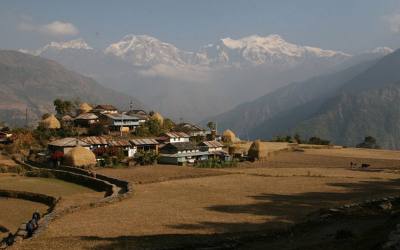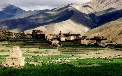
Dolpa is one of the most isolated areas of Nepal. It lies far behind the Dhaulagiri mountain range and until very recently, Dolpa was cut off almost completely from the development of the outside world. The population is very diverse, with Hindu’s living in the lower parts and Buddhist people from Tibetan background living in the higher parts of Dolpa.
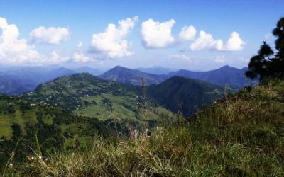
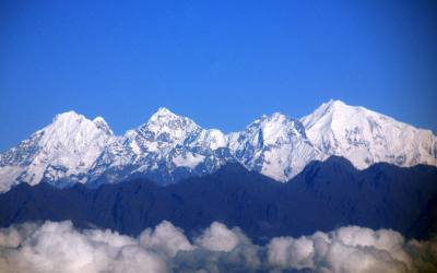
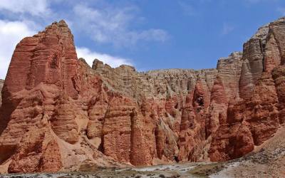
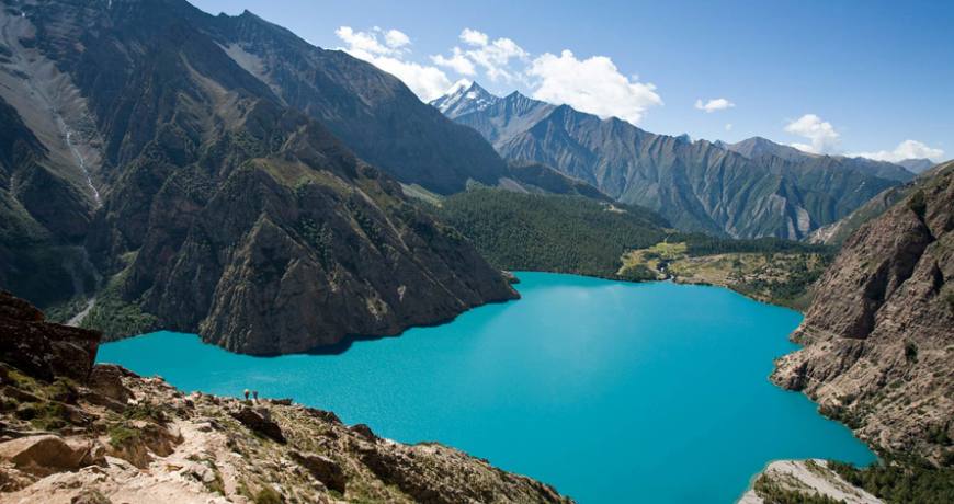
Hiking in Dolpa is an experience never to be forgotten. It gives you a unique opportunity to experience life in the remote highlands. You walk through beautiful landscapes, passing through pine forests alongside wild rivers with views to beautiful snowcapped mountains. If you are going to Dho Tarap as well, you hike through desolate landscapes surrounded by rocks in all kind of colors and formations. The Phoksundo Lake is of an incomparable beauty, with its deep blue and emerald colors, surrounded by steep abvv zxbold rocks. Besides, you will pass through authentic Buddhist and Bonpo villages, and get in contact with untouched Tibetan culture. Bonpo religion is the oldest spiritual tradion of Tibet. It is very much related with Buddhism, but has more shamanistic and animistic influences, which gives a mythical appeal to Dolpa.
Dolpa was first opened to trekkers in 1990 and Inner Dolpo only in 1992. In spite of it’s beautiful landscapes and authentic culture, up till now it’s still a region which gets very few tourists. You can walk for days without meeting any other foreign trekkers. A very special experience as well!
Dolpa is one of the most isolated areas of Nepal. It lies far behind the Dhaulagiri mountain range and until very recently, Dolpa was cut off almost completely from the development of the outside world. The population is very diverse, with Hindu’s living in the lower parts and Buddhist people from Tibetan background living in the higher parts of Dolpa. Hiking in Dolpa is an experience never to be forgotten. It gives you a unique opportunity to experience life in the remote highlands. You walk through beautiful landscapes, passing through pine forests alongside wild rivers with views to beautiful snowcapped mountains. If you are going to Dho Tarap as well, you hike through desolate landscapes surrounded by rocks in all kind of colors and formations. The Phoksundo Lake is of an incomparable beauty, with its deep blue and emerald colors, surrounded by steep bold rocks. Besides, you will pass through authentic Buddhist and Bonpo villages, and get in contact with untouched Tibetan culture. Bonpo religion is the oldest spiritual tradion of Tibet. It is very much related with Buddhism, but has more shamanistic and animistic influences, which gives a mythical appeal to Dolpa. Dolpa was first opened to trekkers in 1990 and Inner Dolpo only in 1992. In spite of it’s beautiful landscapes and authentic culture, up till now it’s still a region which gets very few tourists. You can walk for days without meeting any other foreign trekkers. A very special experience as well!
Day 01: Flight Kathmandu-Nepalgunj
Day 02: Flight Nepalgunj-Juphal (2475 m), walk to Chhepka (2838 m) 6 hrs
Day 03: Sanduwa/Amchi Hospital (3110 m) to Ringmo/Phoksundo Lake (3733 m) 3 hrs
Day 04: Ringmo/Phoksundo Lake (3733 m), free day
Day 05: Ringmo/Phoksundo Lake (3733 m) to Chhepka (2838 m) via Rechi (2940 m) 7 hrs
Day 06: Chhepka (2838 m) to Juphal (2475 m) 6 hrs
Day 07: Flight Juphal-Nepalgunj-Kathmandu
Day 01: Flight Kathmandu-Nepalgunj
To get to Dolpa, you have to fly to Nepalgunj first. Nepalgunj is a steaming hot city in South Western Nepal, in the lowlands of Terai, close to the Indian border. Take a cycle riksha for a ride in town. You pass the hustle and bustle of the bazaar and see horse carts full with people going to or coming from the Indian border.
Day 02: Flight Nepalgunj-Juphal (2475 m), walk to Chhepka (2838 m) 6 hrs
It’s a spectacular 35 minutes flight over steep mountain ridges to Juphal. Juphal airport is just a gravel airstrip amidst the mountains and Juphal a small, mostly Hindu village. From Juphal you walk down over a small path among fields with wheat and vegetables to the Thuli Bheri River. It’s a pretty steep decline of about 1 hour. Down at the river, the path is rather flat and large. After some 45 minutes you pass a small Hindu village, Kalagaonda, where you could stop for a tea. From here it’s another 45 minutes to a big iron suspension bridge, the Dhim Bridge of 99 m long. This is the entrance to the Shey Phoksundo National Park (SPNP). After crossing the bridge you have to cross a wooden bridge, after which you find the checkpost of the Park. SPNP is Nepal’s largest National Park, established in 1984, with an area of 3,555 km⊃2;. It aims to conserve the Trans-Himalayan ecosystem and the Tibetan type of flora and fauna. In 1998, and area of 1,349 km⊃2; surrounding the park was declared as buffer zone, which is jointly managed by the park and local communities. You have to pay 1000 rps entrance fee (except persons from SAARC countries, who pay 100 rps).
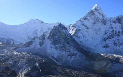
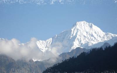
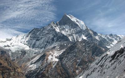
The path follows the Suli Khola River. It’s an easy, fairly level walk through a bit dry, open landscape. Behind you, you can see the snowcapped Kang Tokal (6294 m).
After more or less an hour walking, you reach Kageni (2413 m). In Kageni is a small hotel with a campsite, Raju Hotel, where you could stop for lunch or stay for the night.
Close to Kageni is Raktang (2421 m), a winterplace for people from Ringmo, where you can camp as well. After Raktang, the path starts to climb, with some short descends in between. More or less half an hour after Raktang, you enter the forest. It’s a beautiful walk, alongside the wild flowing river, which at some parts is beautiful emerald green. You walk alongside pine trees, like spruce, fir, juniper and cypress and pass small bamboo forests and walnut trees. At the other side of the river, the rocky slope goes up steeply and is dotted with pine trees as well.
After about an hour, you arrive at Shyanta (2520 m). Here honey is cultivated. It’s a nice place for a tea with honey! Zipping your tea, you can see the bees going in and out the beehives, made from tree trunks. More or less an hour after Shyanta, you reach Chhepka. Chhepka is a small village, surrounded by fields of barley. It has three hotels, La lee gurans Hotel and Lodge, Hotel Jharana and Yak Hotel and Lodge.
Day 03: Sanduwa/Amchi Hospital (3110 m) to Ringmo/Phoksundo Lake (3733 m) 3 hrs
It’s a short hike today to Ringmo and the Phoksundo Lake. The first half an hour is Nepali flat again, following the river. After this, it’s a long and sometimes steep climb over a winding and a bit dusty path. Soon you will see the river flowing far below you. After 1 to 1½ hour climbing you see a viewpoint with Buddhist flags. From the viewpoint you will see a spectacular waterfall of 167 meters high, the Suligad Waterfall (also called Phoksundo Waterfall), Nepal’s highest waterfall. A nice place for a little break. 5 minutes after the viewpoint you will reach the top, and you will have your first view of the view of the Phoksundo Lake. The path is going down now for about half an hour until it gets close to the river again. It’s now half an hour more Nepali flat, walking through the forests, till you reach Ringmo.
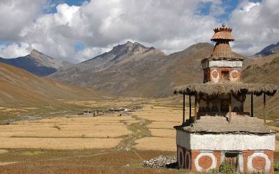
Ringmo is a charming village. People practice the Bonpo religion here. Bonpo is a lot older than Buddhism and goes thousands of years back. It has more animistic aspects than Buddhism. For outsiders it is difficult to see the difference between Bonpo and Buddhism, but one important aspect is that you have to cross their mani walls (low walls with many stones with Buddhist mantra’s carved on it) and chörtens anti clockwise, while according to Buddhist custom, you pass them clockwise. The women wear dark or checked dresses with colorful aprons made from yak wool. You see fewer men in the typical dress, which is a long coat, from which they let one sleeve hanging down. Strolling around the village, you might see women weaving. In Ringmo women make very nice woven products, like belts, bags, shawls and blankets. Most items are made from cotton, but they also sell products made from yak wool. There are a few shops where you can buy this. These shops serve as a general shop as well, and you can fill your stock of biscuits, etc for the rest of the trek. Ringmo has 2 guesthouses, Trekkers Lodge and Sherpa Hotel and Lodge.
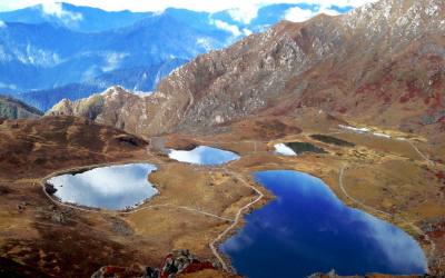
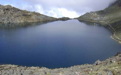
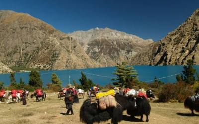
Ringmo lies at the shore of Phoksundo Lake. This lake is of a beauty beyond compare. It has an enchanting deep blue color and is emerald green close to the shore. The water is crystal clear, with not any marine life in it. Steep bold rocks and snowcapped mountains surround the lake. The colors change a bit during the day; you just won’t get enough looking at it. At the shore of the lake, there is a beautiful campsite.
If you want, you can walk a part of the famous Demons Trail from the movie Himalaya (Caravan) of Eric Valli. This is a beautiful movie about the life of people in Dolpa, who bring their yaks over difficult passes bearing salt from Tibet to trade with grain from the lowlands. In the movie, this trail is used during this salt caravan and one of the yaks falls in the lake here. It’s a spectacular trail, going high above the lake . At some parts it gets very narrow due to landslides.
At the other shore, there is a beautiful Bonpo Monastery which you can visit. It’s a 20 minute walk to the monastery through the pine forest. In the monastery you can observe a statue of Thönpa Chenrab, the founder of Bonpo religion, a Buddha who lived thousands of years ago.
Day 04: Ringmo/Phoksundo Lake (3733 m), free day
As the Phoksundo Lake is such a beautiful place, a free day here is recommended.
Day 05: Ringmo/Phoksundo Lake (3733 m) to Chhepka (2838 m) via Rechi (2940 m) 7 hrs
You can walk the following stretch in two short days, or one long day. Walking time to Rechi is about 3 ½ hours (excluding breaks) and from Rechi to Chhepka is 3 ½ hours as well.
The walk to Rechi goes almost entirely through beautiful pine forests, with some bushes, birches and other broadleaf trees in it as well. Leaving Ringmo, the path is rather flat at first, with some ups and downs (Nepali flat) and stays close to the river (Phoksundo Khola). After half an hour however, the path goes away from the river and climbs steeply up the hill. Soon you will see the river far below you. The climb takes about half an hour. At the top you have a beautiful last view of the Phoksundo Lake. 5 minutes after the top, you’ll see the viewpoint again with Buddhist flags, from which you see the Suligad Waterfall/Phoksundo Waterfall. And then it is going down, down and down. The first 45 minutes pretty steep but after that it will be Nepali flat again. More or less one hour after the viewpoint you are at the same level as the river again and you reach the Amchi Hospital. 5 minutes after the Amchi Hospital, you cross a bridge, after which you will find a tent-hotel, which could be a nice tea break. From here, it’s about 1 ½ hour walking to Rechi (2940 m). The path is Nepali flat again, going through the forest, it’s an easy walk. Just before Rechi, there is a tent-hotel with a camping spot, where you can stop for lunch or put up your tent.
The path continues steeply uphill for about 15 minutes (you can see Rechi on the other side of the river) and afterwards goes down steeply as well. Than it’s Nepali flat again. It’s about 3 to 3 ½ hours walking to Chhepka, going up and down, with a couple of steeper climbs and descends, following the river all the time. You notice that you are descending, not only by the higher temperature, but also by the difference in vegetation. For example, you see bamboo again, and big walnut trees. About 1½ hour after leaving Rechi you pass a bridge and the path continues at the right side of the river. One hour and a couple of steep ups and downs later another bridge takes you back to the left side of the river. It’s now another half hour through the forest to reach Chhepka.
Day 06: Chhepka (2838 m) to Juphal (2475 m) 6 hrs
The day starts with a short climb. Then it is most of the times descending, with some small climbs in between. You walk through the forest again, with below you the wild flowing river. After more or less 40 minutes, you arrive at Shyanta (2520 m). About half an hour after leaving Shyanta, you leave the forest, and you suddenly walk through a bit dry landscape. In front of you, you can see the snowcapped Kang Tokal (6294 m).
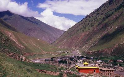
You pass villages like Raktang (2421 m) and Kageni (2413 m) where you arrive about 1 hour 15 min after leaving Shyanta. An hour later, you cross a suspension bridge. Soon after, there is the checkpost of the Shey Phoksundo National Park (SPNP), where you have to show your permit and entree ticket of the SPNP. After the checkpost you have to cross a wooden bridge and walk for a couple of minutes to the big iron suspension bridge (the Dhim Bridge). After crossing the bridge you walk left (west) to Juphal. If you go right (east) here, you go to Dunai, where you arrive in about 45 minutes. Dunai is the headquarters of Dolpa District. It’s a large village, of about 2.500 people, more or less half Hindu and half Buddhist. Up the hill, there is a Buddhist monastery, which is worth a visit.
To Juphal it’s about 2½ - 3 hours from the bridge. The first part goes over a large path. After 45 minutes, you pass through the small village Kalagaonda. About 45 minutes later, you leave the main road and walk over a small path, through fields of barley and wheat, with walnut, peach and apricot trees. It’s a pretty steep climb of about 1 - 1½ hour to reach Juphal. Just before arriving, you pass the Hindu village Dangiwada. Juphal is a large village with a small bazaar where it is nice to look around.
Day 07: Flight Juphal-Nepalgunj-Kathmandu
Early in the morning you fly to Nepalgunj. Especially the first part of the flight through the mountain valleys is spectacular. Later in the day, you fly back to Kathmandu.