The Great Himalaya Trail
About the trail
Trekking, culture, nature and adventure in Nepal
The Great Himalaya Trail is a network of existing treks and trails which together form one of the longest and highest walking trails in the world.
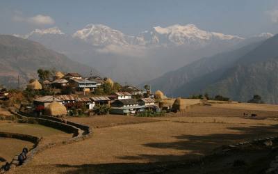
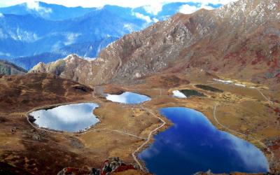
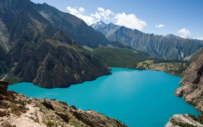
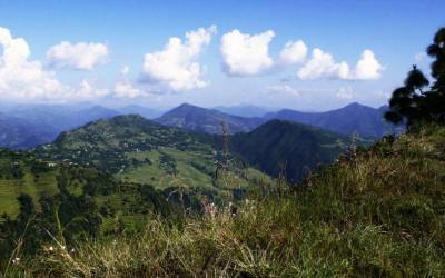
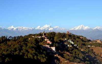
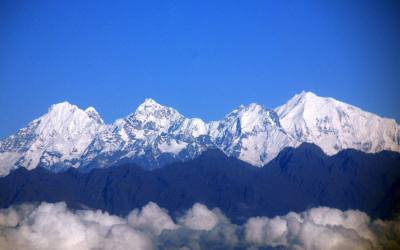
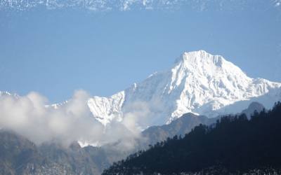
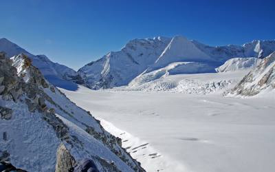
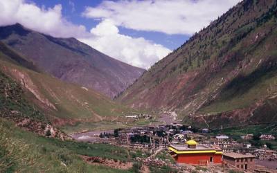
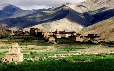
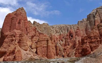
Winding beneath the world’s highest peaks and visiting some of the most remote communities on earth, it passes through lush green valleys, arid high plateaus and incredible landscapes. Nepal’s GHT has 10 sections comprising a network of upper and lower routes (see this map of Nepal), each offering you something different, be it adventure and exploration, authentic cultural experiences, or simply spectacular Himalayan nature.
The trekking route in Nepal
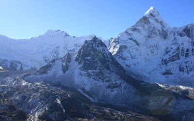
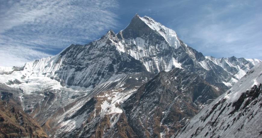
The 1,700 km Nepal section of the trail begins near Kanchenjunga on the eastern border and heads west navigating the domains of eight of the world’s 8000m peaks, from the beautiful but lesser-known Makalu to the famous Everest. It is not the easiest nor most direct route across Nepal, rather a route through the Greater Himalaya. The Nepal section ends in Humla on the Tibetan border.
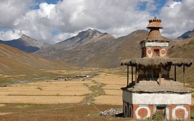
The route offers an incredible diversity in terms of landscapes, flora & fauna, people and culture: from snow leopards to red pandas; from sub-tropical jungle to fragile high-altitude eco-systems; from the famous Sherpas, to Shamanism, to the ancient Bön Buddhist culture found still in Dolpa.
National Geographic Adventure Magazine‘s Jame’s Vlahos observes, “Nepal’s mountains are minimally developed, but they offer a wealth of trade and pilgrimage routes. The GHT elegantly connects these existing paths without blazing a single new trail.”
The Nepal section is part of a longer alpine adventure traversing the spine of the Himalaya from Bhutan to Pakistan. These sections are currently being researched, trekked and documented. There still is a a lot of Great Himalaya Trail exploring yet to be done!
Making a difference
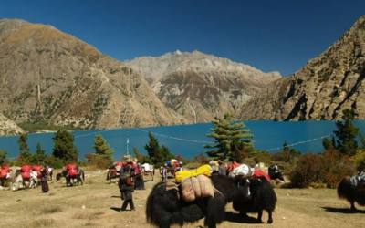
Nepal is a poor country and tourism contributes an important 4% of GDP. However this is concentrated, as far as trekking is concerned, in the 3 most popular areas of Solo Khumbu (Everest) region, Annapurna region and Langtang.
By trekking off the the beaten track, you will making a direct difference to communities in these areas by spending money on food, accommodation or services such as guides, porters and cooks. And you’ll be getting to some incredible places, meeting people following ancient cultures and having unique experiences.
Many people come to Nepal to get away from the crowds and to seek challenge and adventure, and equally vibrant nature or solitude. That is more than possible in Nepal.
Few will have the time to attempt the whole route, so it is broken up into sections and short treks along the trail. There are many more places to visit in Nepal than just Annapurna, Everest or Langtang, beautiful as they are! Take with Dolpa for instance…
History
A short history of cross Himalaya trekking
Not many people have walked the length of the Himalayas in the last few decades (and written about it). However there have been some expeditions with the goal either of traversing Nepal or going further trying to traverse the greater Himalaya range
* In 1980, one ‘inspirational’ Mr Shirahata is mentioned in the classic book “Trekking in Nepal” by Toru Nakano as having walked the length of the country from ‘east to west’ in Nepal but no further references or information has been found.
* In 1982, Arlene Blum and travel and adventure writer Hugh Swift became the first westerners to complete a 4,500 km great Himalayan traverse across Bhutan, Nepal and India. Starting from the eastern border of Bhutan, Swift and Blum, climbed up and down the Himalayan range over 6,000m passes and down to river valleys at 600m, gaining and losing an average of 1,000m each day to reach Ladakh. This is documented in her book – Breaking Trail.
* In 1983 two British brothers, Richard and Adrian Crane ran the Himalayas, from before Kanchenjunga to beyond Nanga Parbat in less than 100 days. According to the Crane’s book, “Running the Himalayas”,
In 1980 an Indian army team set out from Arunchal Pradesh in India’s north east corner and, after one and a half to two years of travel along a high mountain route, they finished their journey just north of Leh in the Ladakh region of the Karakorams…. it progressed in ‘relay’ fashion and possibly no one member stayed with the expedition for the full course.
They also met the British Women’s Trans-Himalayan Expedition who set of from Sikkim in January 1983 and used buses where necessary on their journey. The Crane’s were however…
…travelling super-light. One rucksack, one sleeping bag, one set of clothes, one pair of shoes, and shared between us: map, diaries, camera, penknife, water jar and two plastic teaspoons. No guides, no porters, no shelter, no food, no water. And we would be running. Looked at logically, the idea was preposterous.
* Similarly, in 1994 the French duo of Paul-Eric Bonneau and Bruno Poirier made a crossing of the Himalayas in Nepal in 42 days (October 21 – December 1, 1994) and called their adventure “Trans-Nepal-Himalaya”. They travelled 2000 km (+ / -55 000 m) between Pashupatinagar (eastern border) and Mahakali (western border) including Everest base camp.
* Then nearly two decades later in 2003, Rosie Swale-Pope ran the length of Nepal, and early Great Himalayan Trail route, with a support team, doing an estimated 1,700km in 68 days to raise money for the charity Nepal Trust.
* Dr Gillian Holdsworth walked a similar route in 2007 which is documented on the British Nepal Medical Trust website.
* Between 2008 and 2011 Jean-Claude Latombe walked a winding trail across Nepal in two sections of 56 and 53 days. His website has a wonderful collage of images of the people and landscapes he encountered.
* In 2010 Sean Burch completed a route across Nepal in 49 days with the help of Nepal Trust
* in 2011 Shawn Forry and Justin Lichter walked an unsupported trek of 57 days across Nepal.
What is the trail?
Until recently the trail remained an undefined idea – there was no one, logical trail.
In 2006 the Dutch development agency SNV and the International Centre for Integrated Mountain Development (ICIMOD) in Kathmandu proposed developing an official Great Himalaya Trail from near Kangchenjunga in the east to Api-Saipal in the far west of Nepal. If opening up wild and remote parts of the country could attract trekkers away from the busy areas like Everest, it could benefit more of the 1.8 million people living in the mountains.
Their plans are moving ahead involving all of the affected stakeholders: from renowned mountaineers and trekking guides to the Nepal Tourist Board and the Trekking Agents Association to the village Development Committees in the remote areas the trek passes through.
However it was early 2009 that truly gave birth to a Great Himalaya Trail in Nepal. Robin Boustead supported by his wife Judy Smith and friends who walked the trail in stages beginning in September 2008. It took a lot of research to identify a true high-alpine route that was feasible for trekkers. Robin said:
“If someone gathered enough information on that area, it would be a great trek for everyone”
Robin was that someone and he has documented his route meticulously using GPS. The route, distances, elevations, water sources, villages and camp sites will all be detailed in a guide book to be released early 2010.
Still, the Great Himalaya Trail is new and will evolve over the coming years through the preferences and suggestions of trekkers completing the route or sections of it. This is why it is so exciting to get on the trail now.
Day01: Flight or by bus from kathmandu to Biratnagar. Over night on hotel.
Day02: Biratnagar to Suketar by flight than trek to Lai kharka (2276m) camp
Day03: Lai Kharka to Keswa (2120m) 6-7 hours of walking
Day04: keswa to Mamangkhe(1920m) 5-6 hour of walking
Day05:Mamangkhe to Yamphudin (2080m) 6-7 hour of walking
Day06: Yamphudin to Amja Khola (1830m) 6 hour of walking
Day07: Amja Khola to Toronton (2995m) 6 hour of walking
Day08: Toronton to Tseram (3770m) 6 hour of walking
Day09: Tseram to sinonla pass and to Phedi 6-7 hour of walking
Day10: Sinonla phedi to Ghunsa (3595m) 5-6 hour of walking
Day11: Ghunsa to Kambachen ( 4000m) 6 hour of walking
Day12: Kambachen to Lhonak (4500m) 6 hour of walking
Day13: Lhonak to Pangpema (4800m) 6 hour of walking
Day14: Pangpema to Ramtang (3500m) 6-7 hour of walking
Day15:Ramtang to Ghunsa (3595m) 6 hour of walking
Day16:Ghunsa to Amjilasa (2510m) 6 hour of walking
Day17: Amjilasa to Chirwa (2100m) 6-7 hour of walking
Day18: Chirwa to Lugthung (2000m) 6 hour of walking (Note: can come back to kathmandu from suketar with in 2 days)
Day19: Lugthung to Donje (2850m) 6 hour of walking
Day20:Donje to Topkegola (3500m) 6 hour of walking
Day21: Rest day and Explore
Day22: Topkegola to Pahakhola( Ikhawa khola) 6 hour of walking
Day23:Ikahawa Khola to Num ( Note can come to kathmandu from Tumlingtar with in 3 days)
Day24: Num to Sedua
Day25: Sedua to Tahigoau
Day26: Tahigoau to Khongma
Day27: Khongma to Mumbuk
Day28:Mumbuk to Yangle kharka
Day29: Yangle Kharka to Merek
Day30: Merek to shersong
Day31: Shersong to Makalu base camp
Day32: Makalu base camp rest and explore
Day33: Makalu base camp to Sherpani col
Day34: Sherpani col to west col
Day35: west col to Baruntse base camp
Day36: Baruntse base camp to Amphulapcha phedi
Day37: Amphulapcha phedi to pass than to another Phedi
Day38: other phedi to chukung valley( Note: can come back to kathmandu from Lukla with in 4 days.)
Day39: Chukung to Lobuche
Day40: Lobuche to kalapathar and return back to Lobuche
Day41: Lobuche to Zhongla
Day42:Zhongla to Thangnak
Day43: Thangnak to Gokyo
Day44: Rest day and explore
Day45: Gokyo to Renjo la pass than to Murlung
Day46: Murlung to Thame ( Note: can come to kathmandu from Lukla with in 3 days)
Day47: Thame to Thyongbo
Day48: Thyongbo to Tashi lapcha
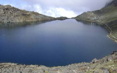
Day49: Tashi Lapcha to Tsho Rolpo lake
Day50: Tsho Rolpo lake to Na goau
Day51: Na Goau rest and explore
Day52: Na Goau to Beding
Day53: Beding to Chauri Kharka
Day54: Chauri Kharka to Simigoau
Day55: Simigoau to Surya Dobhan ( Note can come back to kathmandu with in 2 days of walk)
Day56: Surya Dobhan to Salleri
Day57:Salleri to Loting
Day58: Loting to Bigu Gompa
Day59: Bigu Gompa to Dolangse
Day60: Dolangse to Barabise bazaar (Note can come to kathmandu by bus)
Day61: Drive for one hour to Dhunga Gadhi
Day62: Dhunga Gadhi to Sherpa Goau
Day63: Sherpa Goau to Nautale Kharka
Day64: Nautale Kharka to Tembathang
Day65: Tembathang to Pach pokhari(3500m)
Day66: Pach Pokhari to Timan Phedi (4000m)
Day67: Timan Phedi to Tilman’s Pass to Langsisa Glacier
Day68:Langsisa Glacier to Langsisa Kharka (4080m)
Day69: Langsisa Kharka to Kyangjing Gompa (3870m)
Day70: Kyangjing Gompa to lama Hotel (2400m)
Day71: Lama Hotel to Syaprubesi (1460m) ( Note can come back to kathmandu by bus)
Day72: Syaprubesi to Lingling (1773m)
Day73: Lingling to Tatopani(2607m)
Day74: Tatopani to Gotlang (2338m)
Day75: Gotlang to Somdang( 3270m)
Day76: Somdang to Jageshwari kund (3970m)
Day77: Jageswari kund to Paldor base camp
Day78: Paldor base camp to Somdang
Day79: Somdang to Tibling
Day80: Tibling to Labu (1600m)
Day81: Labu to Khola besi (1800m) ( note can come back to kathmandu from Arughat bazaar with in one day)
Day82:Khola besi to Jagat (1360m)
Day83: Jagat to ekle ghar (1650m)
Day84: Ekle Ghar to Pewa (2340m)
Day85: Pewa to Namrung (2550m)
Day86:Namrung to Sama Goau (3360m)
Day87: Sama Goau to Samdo (3780m)
Day88: Rest Day and Explore
Day89: Samdo to Dharmasala (4460m)
Day90: Dharmasala to Bhimthang (3630m) via Larke pass ( 5220m)
Day91: Bhimtang to Dharapani (1860m) ( Note can come to Kathmandu from Bhulbhule with in 4 days)
Day92: Dharapani to Koto (2600m)
Day93:Khoto to Chacha (3100m)
Day94: Chacha to Kyang ( 3820m)
Day95: Kyang to Phu (3980m)
Day96: Phu to Chako(3680m)
Day97: Chako to Naar (4110m)
Day98:Naar to Dho Lapse Khola (4400m) walking all day via Lapse khola, chaungseng kharka and Chhubeche Kharka
Day99: Dho Lapse Khola to Lungre (4600m) walking through Lapse Khola all day
Day100: Lungre to Teri Bhanjyang phedi (5000m)
Day101: Teri Bhanjyang Phedi to Tangya (3240m)
Day102: Tangya to yara (3650m)
Day103: Yara to Lhori (4000m)
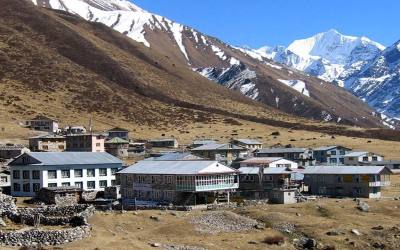
Day104: Lhori to Lo-Mathang (3780m)
Day105: Rest Day and explore
Day106: Lo-Mathang to Tsarang (3650m) and to Lo-ghekar (3950m)
Day107: Lo Ghekar to Ghiling (3510m)
Day108: Ghiling to Samar (3700m)
Day109: Samar to Chhuksang (3050m)
Day110: Chhuksang to Yak Kharka
Day111: Yak Kharka to Sangda Goau
Day112:Sangda Goau to Sangdak
Day113:Sangdak to Niwar Phedi
Day114: Niwar Phedi to Thajang Khola
Day115: Thajang Khola to Chharka
Day116: Chharka to Khajiyang Khola
Day117: Khajiyang Khola to Nomad Tends
Day118: Nomad Tends to Tingkhyu(4110m)
Day119: Tingkhyu to Simen Gaon (3850m)
Day120: Simen Gaon to Kova
Day121: Kova to Saldang
Day122: Saldang to Nanguga
Day123: Nanguga to Shey Gompa
Day124: Shey Gompa Rest day and explore( Note can come to kathmandu from Jhuphal with in 5 days of walking and flight to Nepaljung than to Kathmandu)
Day125: Shey Gompa to Tra
Day126: Tra to Bijorgaou (3801m)
Day127: Bijorgaou to Langu Khola
Day128: Langu Khola to Jhopala
Day129: Jhopala to Namlung Khola
Day130: Namlung Khola to Dolphu
Day131: Dolphu to Chutai
Day132: Chutai to Mugu Gaou
Day133: Mugu Gaou to Sim Chaur
Day134: Sim Chaur to Mangri
Day135: Mangri to Lumsa
Day136: Lumsa to Rara Lake ( Note can come from Jumla to Kathmandu with in 6 days by walk and by flight)
Day137: Rara lake to Banaba
Day138: Banaba to Jogimara
Day139: Jogimara to Darma
Day140: Darma to Mara Gaon
Day141: Mara Gaon to Kharpal
Day142: Kharpal to Kharpunath
Day143: Kharpunath to simikot ( Note can come to kathmandu by air to Nepalgung than to Kathmandu)
Day144:Simikot to Kermi
Day145: Kermit to Yanger
Day146: Yanger to Yara
Day147: Yara to Hilsa
Day148: Hilsa to Manepeme
Day149: Manepeme to Til Khola
Day150: Til Khola to Jang
Day151: Jang to Tankchhe or Talung
Day152: Talung to Dharmashala
Day153; Dharmashala toLek Dhinga
Day154: Lek Dhinga to Simikot
Day155: Simikot to Nepaljung by air than to Kathmandu.
The Great Himalaya Trail
About the trail
Trekking, culture, nature and adventure in Nepal
The Great Himalaya Trail is a network of existing treks and trails which together form one of the longest and highest walking trails in the world.
Winding beneath the world’s highest peaks and visiting some of the most remote communities on earth, it passes through lush green valleys, arid high plateaus and incredible landscapes. Nepal’s GHT has 10 sections comprising a network of upper and lower routes (see this map of Nepal), each offering you something different, be it adventure and exploration, authentic cultural experiences, or simply spectacular Himalayan nature.
The trekking route in Nepal
The 1,700 km Nepal section of the trail begins near Kanchenjunga on the eastern border and heads west navigating the domains of eight of the world’s 8000m peaks, from the beautiful but lesser-known Makalu to the famous Everest. It is not the easiest nor most direct route across Nepal, rather a route through the Greater Himalaya. The Nepal section ends in Humla on the Tibetan border.
The route offers an incredible diversity in terms of landscapes, flora & fauna, people and culture: from snow leopards to red pandas; from sub-tropical jungle to fragile high-altitude eco-systems; from the famous Sherpas, to Shamanism, to the ancient Bön Buddhist culture found still in Dolpa.
National Geographic Adventure Magazine‘s Jame’s Vlahos observes, “Nepal’s mountains are minimally developed, but they offer a wealth of trade and pilgrimage routes. The GHT elegantly connects these existing paths without blazing a single new trail.”
The Nepal section is part of a longer alpine adventure traversing the spine of the Himalaya from Bhutan to Pakistan. These sections are currently being researched, trekked and documented. There still is a a lot of Great Himalaya Trail exploring yet to be done!
Making a difference
Nepal is a poor country and tourism contributes an important 4% of GDP. However this is concentrated, as far as trekking is concerned, in the 3 most popular areas of Solo Khumbu (Everest) region, Annapurna region and Langtang.
By trekking off the the beaten track, you will making a direct difference to communities in these areas by spending money on food, accommodation or services such as guides, porters and cooks. And you’ll be getting to some incredible places, meeting people following ancient cultures and having unique experiences.
Many people come to Nepal to get away from the crowds and to seek challenge and adventure, and equally vibrant nature or solitude. That is more than possible in Nepal.
Few will have the time to attempt the whole route, so it is broken up into sections and short treks along the trail. There are many more places to visit in Nepal than just Annapurna, Everest or Langtang, beautiful as they are! Take with Dolpa for instance…
History
A short history of cross Himalaya trekking
Not many people have walked the length of the Himalayas in the last few decades (and written about it). However there have been some expeditions with the goal either of traversing Nepal or going further trying to traverse the greater Himalaya range.
* In 1980, one ‘inspirational’ Mr Shirahata is mentioned in the classic book “Trekking in Nepal” by Toru Nakano as having walked the length of the country from ‘east to west’ in Nepal but no further references or information has been found.
* In 1982, Arlene Blum and travel and adventure writer Hugh Swift became the first westerners to complete a 4,500 km great Himalayan traverse across Bhutan,Nepal and India. Starting from the eastern border of Bhutan, Swift and Blum, climbed up and down the Himalayan range over 6,000m passes and down to river valleys at 600m, gaining and losing an average of 1,000m each day to reach Ladakh. This is documented in her book – Breaking Trail.
* In 1983 two British brothers, Richard and Adrian Crane ran the Himalayas, from before Kanchenjunga to beyond Nanga Parbat in less than 100 days. According to the Crane’s book, “Running the Himalayas”,
In 1980 an Indian army team set out from Arunchal Pradesh in India’s north east corner and, after one and a half to two years of travel along a high mountain route, they finished their journey just north of Leh in the Ladakh region of the Karakorams…. it progressed in ‘relay’ fashion and possibly no one member stayed with the expedition for the full course.
They also met the British Women’s Trans-Himalayan Expedition who set of from Sikkim in January 1983 and used buses where necessary on their journey. The Crane’s were however…
…travelling super-light. One rucksack, one sleeping bag, one set of clothes, one pair of shoes, and shared between us: map, diaries, camera, penknife, water jar and two plastic teaspoons. No guides, no porters, no shelter, no food, no water. And we would be running. Looked at logically, the idea was preposterous.
* Similarly, in 1994 the French duo of Paul-Eric Bonneau and Bruno Poirier made a crossing of the Himalayas in Nepal in 42 days (October 21 – December 1, 1994) and called their adventure “Trans-Nepal-Himalaya”. They travelled 2000 km (+ / -55 000 m) between Pashupatinagar (eastern border) and Mahakali (western border) including Everest base camp.
* Then nearly two decades later in 2003, Rosie Swale-Pope ran the length of Nepal, and early Great Himalayan Trail route, with a support team, doing an estimated 1,700km in 68 days to raise money for the charity Nepal Trust.
* Dr Gillian Holdsworth walked a similar route in 2007 which is documented on the British Nepal Medical Trust website.
* Between 2008 and 2011 Jean-Claude Latombe walked a winding trail across Nepal in two sections of 56 and 53 days. His website has a wonderful collage of images of the people and landscapes he encountered.
* In 2010 Sean Burch completed a route across Nepal in 49 days with the help of Nepal Trust
* in 2011 Shawn Forry and Justin Lichter walked an unsupported trek of 57 days across Nepal.
What is the trail?
Until recently the trail remained an undefined idea – there was no one, logical trail.
In 2006 the Dutch development agency SNV and the International Centre for Integrated Mountain Development (ICIMOD) in Kathmandu proposed developing an official Great Himalaya Trail from near Kangchenjunga in the east to Api-Saipal in the far west of Nepal. If opening up wild and remote parts of the country could attract trekkers away from the busy areas like Everest, it could benefit more of the 1.8 million people living in the mountains.
Their plans are moving ahead involving all of the affected stakeholders: from renowned mountaineers and trekking guides to the Nepal Tourist Board and the Trekking Agents Association to the village Development Committees in the remote areas the trek passes through.
However it was early 2009 that truly gave birth to a Great Himalaya Trail in Nepal. Robin Boustead supported by his wife Judy Smith and friends who walked the trail in stages beginning in September 2008. It took a lot of research to identify a true high-alpine route that was feasible for trekkers. Robin said:
“If someone gathered enough information on that area, it would be a great trek for everyone”
Robin was that someone and he has documented his route meticulously using GPS. The route, distances, elevations, water sources, villages and camp sites will all be detailed in a guide book to be released early 2010.
Still, the Great Himalaya Trail is new and will evolve over the coming years through the preferences and suggestions of trekkers completing the route or sections of it. This is why it is so exciting to get on the trail now.
FAQ
Click on a question to see the answer. Feel free to post a new question below in the comments area.
* How much trekking can be done in tea-houses / lodges / homestays etc?
* Who do I go to if want to do the GHT?
* How long does it take to walk the Great Himalaya Trail?
* Can the GHT be walked in sections?
* What permits are required to trek the GHT in Nepal?
* Is there a guidebook for the Great Himalaya Trail?
* Can I ride the Great Himalaya Trail on a mountain-bike?
* What permits are required for trekking in Nepal?
→How much trekking can be done in tea-houses / lodges / home stays etc?
As a generalisation, if you are walking from section to section, you’ll need a tent!
But there are many sections where you’ll find teahouse accommodation. You can walk around Manaslu all the way to Lower Mustang without a tent. You can make a teahouse route through Helambu, Langtang and on to the Tamang Heritage trail. Rolwaling trek has lodge accommodation, but to cross the pass into the Everest region is obviously going to require tents. Everest region has a fantastic network of teahouses.
→Who do I go to if want to do the GHT?
There is a list of companies who can manage logistics for all of the GHT stages on this website, and so far there are just a few. There is already a list of companies who are offering sections of the GHT. But you can certainly approach any reputable trekking company and mention the area you wish to explore, and you should be able to build an itinerary together with them.
→How long does it take to walk the Great Himalaya Trail?
It depends on a few factors. Most people will just choose a section that appeals to them, for instance the Manaslu and Ganesh Himal section, or Humla section and most section treks take from two to four weeks. There is a whole variety of trekking permutations on the GHT and this trek list gives just a few. You can return again and again to complete different sections and so complete the trail over a number of years.
The time taken to hike it all in one go depends on many factors: the weather, your walking speed, route preference, and walking style.
Robin Boustead needed 162 days to walk this trail over two seasons. In the autumn of 2010, Sean Burch travelled from East to West in gruelling 49 days on a mixed route, assisted by the Nepal Trust. World Expeditions ran the first commercial full GHT walk in Nepal starting February 2011 in 157 days. And then Shawn Forry and friend Justin Lichter needed just 47 days of hiking to reach Simikot from Kanchenjunga on a self-sufficient trek.
So there is no straight answer of exactly how long it takes, but start by taking a look at some detailed itineraries to get good idea about how long individual sections might take.
→Can the GHT be walked in sections?
Yes. For most people this would be the best way. An obvious reason is the amount of time it would take – estimates say around 150 days. See Robin Boustead’s comment on this on the main FAQ page.
Another important reason is good weather. The mountains are usually stated to be at their best in April, May and October, November. December is still an excellent time to trek but days are shorter and it’s getting very cold at higher altitudes (see this post about trekking in the Everest Region in winter). Between around February to mid-March winter storms can cover higher trails and block passes. Summer time (June, July, August and early September) is synonymous with monsoon clouds. Many places in Nepal however, such as Humla, Dolpa and Mustang, lie in the rain shadow of the mountains meaning the skies remain clear whereas the rest of Nepal (and the airports) is under cloud.
Each section of the trail has something different to offer in terms of the people and the landscapes. If you are going to get the very most out of your time spent on the Great Himalaya Trail, then its best to make sure you find the best time to enjoy the incomparable views.
→What permits are required to trek the GHT in Nepal?
Some of the trekking areas in Nepal do need trekking permits – it’s sometimes slightly complicated to know where park or restricted area boundaries begin and end. It is better to drop a line to ask a trekking agency to organise this for you and most can arrange this for a just small fee. It is worth doing as it will save you a lot of time and make sure you get the right paperwork.
See here for a list of permits required for certain trekking areas in Nepal.
Additionally, for some areas you may need a TIMS card which is US$ 20 for individuals and US$ 10 for members of groups.
Mountaineering permits
For some groups trekking in remote areas, it may be more sensible to take a permit for a trekking peak. A good example is an exciting, alternative Great Himalaya Trail high route from Phugaon to Lo Mantang and then Lo Mantang to Chharka Bhot (see this on the map of Nepal). then it may be more economical to take trekking peak permits for Bhrikuti Sail and Arniko Chuli.
In all cases it is necessary to buy permits through a registered trekking agent.
→Is there a guidebook for the Great Himalaya Trail?
nepal_trekking_and_the_Great_Himalaya_Trail_Robin_Boustead
More info...
Yes. Robin Boustead, who walked the upper route in 2008/9 has written a guidebook to the trail and it has been published by Trailblazer Guides. This guidebook covers the upper route and so helps you get from Kanchenjunga to Humla or Darchula.
Great Himalaya Trail lower route
If you are interested in the lower route, then so far no specific guidebook is available, however, due to the lower elevations, the ease of access and communications, you’ll find logistics much easier to manage. There are people currently planning to walk this route in 2011 with the aim of documenting trail options, places of interest, accommodation possibilities etc.
Section guides
If you are aiming to trek a smaller section of the GHT, then there are many Nepaltrekking guidebooks that could help you with planning and background information on Nepal, especially for the more established treks.
→Can I ride the Great Himalaya Trail on a mountain-bike?
Biking a GHT section, Lower Mustang
Biking in the Kali Gandaki gorge
Can you ride the Great Himalaya Trail on a mountain-bike? Possibly – it just depends how much you like carrying your bike. The Great Himalaya Trail, is a network of walking trails. The upper route, finding its way through the Great Himalaya range, has quite a number of rocky and steep sections – there are many high passes and some snowy and an number even glaciated for which crossing them is described as mountaineering.
You could theoretically take your bike the whole way, but it would be a shame to waste so much time carrying it.
Still, parts of the trail are bike-able. People manage to bike in these conditions. Every year there is the Yak Attack which goes around the Annapurna circuit, over the 5400m Thorung La (which is part of the Great Himalaya Trail) and down the recently completed road to Beni. The maps page tells you just how much is ride-able. But then this is a very well established trekking area with improved trails. Less frequented areas have less developed trails.
There is also the lower route. This has been much less explored but it’s lower elevation offers some promise for the adventurous.
All across Nepal, simple dirt roads are being constructed up into the higher reaches of valleys which are worth exploring. Around the Kathmandu valley there many days worth of excellent single track, forest trails, ridge rides and great views. If you are really keen on mountain biking in Nepal, it is best to contact one of the several excellent mountain biking companies here in Kathmandu and work out where the best places to go would be. In the off seasons, they are often trying out new places and putting together new routes.
→What permits are required for trekking in Nepal?
Trekking and restricted area permits for Nepal
A real life trekking permit
If you are applying for a mountaineering permit, which may apply for the Tashi Labsta, Saribung or one of many other trekking peaks, then you will need to fill in a bio-data form and pass this to your agency. You can do this online and add signature and photograph to the form when in Kathmandu.
Kanchenjunga
Trekking permit US$ 10 issued to groups of two or more trekkers applying through an agency / outfitter.
NRP 2000 (~EUR 20 / US$ 30) to enter Kanchenjunga Conservation Area. An agent in Kathmandu should be able to organise this too. Otherwise see http://dnpwc.gov.np/. The office is near Babarmahal.
Makalu Barun National Park
NRP 1000 park fee payable ‘on the door’ so to speak, or in advance in Kathmandu via DNPWC.
Tims card ( Trekking information management system will cost US$ 20.00 per person)
Everest region (Solo Khumbu)
Sagamatha National Park entrance fee NRP 1000 payable at Monjo on the route from Lukla so better paid in advance if not entering this way i.e. along the GHT route.
Tims card Required US$ 20.00 per person
Ghauroshanker National park
NRS 2000.00 Per person
Tims card Required US$ 20.00 per person
Helambu & Langtang
NRP 1000 fee to enter Langtang National Park (payable at checkposts). NRP 250 to pass through Shivapuri National Park if walking in from Kathmandu, also payable at checkposts.
Tims card required US$20.00 Per person
Manaslu region
Here you will enter the Manaslu Conservation Area for which a payment of NRP 2000 must be made.
To enter this area you must trek with a registered guide in a group of two or more. Permit fee is:
* Peak season (Sep, Oct, Nov) – US$ 70 for the first week and US$ 10 per day thereafter.
* Other times – US$ 50 for the first week and US$ 7 per day thereafter.
Nar-Phu
If you take this detour to this ‘hidden-land’ a permit costs US$90 in peak season (Sep, Oct, Nov) or US$70 for other times
Annapurna / ACAP
ACAP permit is NRP 2000 to be paid in advance in Kathmandu or Pokhara. Two passport photos also required.
Tims card Required US$ 20.00 per person
Upper Mustang
Detouring into the restricted area of Upper Mustang is costly but memorable – if you are interested in different cultures, in nature, in Tibet and really want to travel back in time, then it is arguably cheap at the price. The fee is a minimum of US$ 500 (covers up to 10 days) plus US$ 50 per day thereafter. Additionally the permit is issued for a declared date range so incorporating into a long trek needs to keep this in mind. There are also additional requirements on cooking (take your own fuel and food) and rubbish (bring it out) which means additional logistics and bureaucracy as you must return to the ACAP office after your visit. However, given that tea-house trekking is easy, that the road up to Tangbe means that gas bottles can be purchased along the route, that electricity now reaches Samar and hydro-electricity is available in other villages, it is less of a worry that 18 years before when the rules were implemented. Plus the permit checking is less than rigourous and you can easily leave towards Muktinath. That is not to say you should be attentive of the fragile environment, but it should not put you off grabbing your back packs and heading up there.
Shey Phuksumdo National Park
NRP 1000 entry fee payable at Suli Gaad (near Dunai) or in Kathmandu.
Inner Dolpa
Same fee structure as Upper Mustang
Mugu
US$ 90 for first week then US$ 15 per day.
Rara National Park
NRP 1000 park entrance fee to be paid.
Humla
US$ 50 per week and US$ 7 per day for each subsequent day.
Saipal
US$ 90 for first week then US$ 15 per day.
Restricted area permits
To recap, Humla, Kanchenjunga, Lower and Upper Dolpa, Upper Mustang, Manaslu, Mugu, Nar-Phu are all restricted areas which means you have to get your permits through a trekking agent / outfitter. Permits are issued for groups of two or more so if you are alone then you probably can just double the fees mentioned above and buy two permits.
Trek itinerary and prices are on the request. for details of this trekking such as map, itinerary and photos please visit website in below.
Source www.thegreathimalayatrail.org