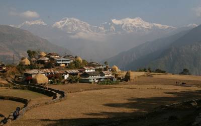
Inner Dolpo has a magical, mythical appeal. The landscapes here are even more desolate than on the Dolpa Circuit and the villages even more isolated and pure. In Inner Dolpo century old Buddhist traditions, interwoven with shamanistic influences, are still an important part of daily life. The villages, gompa’s and people you meet during this trek will leave an unforgettable impression on you.
Inner Dolpo is a restricted area, for which a fee is charged of US$ 500 for the first 10 days, and US$ 50 for each additional day. Besides, there is a maximum of the number of foreigners that can enter Inner Dolpo each year. Currently this maximum is put at 250 people. This makes Inner Dolpo a very special and exclusive place.
The trekking brings you to Shey Gompa, which is often referred to as the spiritual heart of Inner Dolpo. It’s a magical place, situated at the base of Crystal Mountain, which is visited by hundreds of pilgrims each year. They make a kora (circuit) of the Crystal Mountain, Dolpo’s own version of Mount Kailas. The trek is an extension of the Dolpa Circuit, done in the other direction.
It is a very strenuous hike. You have to cross three passes, Kang La/ Ngadra La of 5350 m, the Shey La of 5000 m and Jeng La of 5110 m. These crossings involve long climbs and long descends. Besides, you stay above 4000 meters for a long time, with very cold nights. But the unforgettable landscapes, the views from the passes and the contacts with an untouched culture make it all worth it.
Leaving from Kathmandu, it’s a 20 days trip, but it can be extended as well, depending on the length of your walking days.
There are guesthouses in Juphal, Dunai, Kageni, Chhepka, close to Sanduwa (next to the Amchi Hospital), Ringmo, Shey, Saldang, Dho and Lingdo. At the other places you have to camp.
Walking times are of course a guideline and differ from person to person. The times mentioned, are excluding breaks.
Day 01: Flight Kathmandu-Nepalgunj.
Day 02: Chhepka (3982 m) to Sanduwa/Amchi Hospital (3110 m) 6 hrs
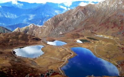
Day 03: Sanduwa/Amchi Hospital (3110 m) to Ringmo/Phoksundo Lake (3733 m) 3 hrs
Day 04: Ringmo/Phoksundo Lake (3733 m), free day
Day 05: Ringmo/Phoksundo Lake (3733 m) to Chuneba (3639 m) 5 hrs
Day 06: Lakeside camp (3639 m) to Snowfields Camp (4400 m) 7 hrs
Day 07: Snowfields Camp (4400 m) to Shey Gompa (4310 m) via Kang La (5375 m) 6 hrs
Day 08: Restday Shey Gompa (4350 m)
Day 09: Shey Gompa (4350 m) to Namgung (4430 m) via Shey La (5000 m) 6 hrs
Day 10: Namgung (4400 m) to Saldang (4060 m) 3 hrs
Day 11: Saldang (4060 m) to Sibu (4200 m) 5 hrs
Day 12: Sibu (4200 m) to Lagmo Che (4570 m) 4 hrs
Day 13: Lagmo Che (4570 m) to Tokyu (4209 m) via Jeng La (5110 m) 7 hrs
Day 14: Tokyu (4209 m) to Dho Tarap ( 4080 m) 2 hrs
Day 15: Dho Tarap (4080 m) to Sisaul (3750 m) 4 hrs
Day 16: Sisaul (3750 m) to Laina Odar (3370 m) 7-8 hrs
Day 17: Laina Odar (3370 m) to Lingdo (2391 m) 5 hrs
Day 18: Lingdo (2391 m) to Dunai (2140 m) 5 hrs
Day 19: Dunai (2140 m) to Juphal (2475 m) 3½ hrs
Day 20: Flight Juphal-Nepalgunj-Kathmandu
Day 01: Flight Kathmandu-Nepalgunj.
To get to Dolpa, you have to fly to Nepalgunj first. Nepalgunj is a steaming hot city in South Western Nepal, in the lowlands of Terai, close to the Indian border. Take a cycle riksha for a ride in town. You pass the hustle and bustle of the bazaar and see horse carts full with people going to or coming from the Indian border.
Day 02: Chhepka (3982 m) to Sanduwa/Amchi Hospital (3110 m) 6 hrs
The path goes entirely through the forest today. Most of it is Nepali flat: sometimes going up and sometimes going down, with a couple of steeper climbs and descends, following the river all the time. It’s about 3 ½ - 4 hours walking to Rechi. The village Rechi is at the other side of the river. It’s a very small village and consists of just a couple of houses and a primary school. Just after passing Rechi, there is a tent-hotel with a camping spot, where you could stop for a dahl bath (the typical Nepali dish, consisting of lentils (dahl), rice (bath) and normally a curry dish (tarkary) or noodlesoup. Tent-hotels are big Tibetan tents, set up to serve food and drinks to travelers. Besides local restaurants, they serve as a shop as well, and you can buy a variety of items here, like biscuits, juice, Lhasa beer, shampoo, etc.. They mostly cater to local people, but small groups of foreign travelers use them as well. You can put up your tent here as well, if you want to call it a day.
It’s about 2 hours walking to the Amchi Hospital, which is just after Sanduwa. The path is Nepali flat again, so it’s an easy walk. The walk goes almost entirely through beautiful pine forests, with some bushes, birches and other broadleaf trees in it as well. The path stays close to the river (which is called Phoksundo Khola now). On the way you encounter local people with their mules or jhopas (crossbreed between yak and cow) loaded with stuff to sell. 5 minutes before reaching the Amchi Hospital you pass a tent-hotel, which could be a good place to camp and/or have diner. Just after this you see the Boarding School, which also serves the children of Ringmo and is financed by a USA based organization. Just after the school, you arrive at the Amchi Hospital. This is a very interesting place and worth a visit. In fact it is more a clinique, which is highly frequented by local people, but unfortunately not so often by tourists. An Amchi is a doctor who is educated in traditional Tibetan medicine, and always is a lama (monk) as well. Tibetan medicine has a tradition of thousands of years and uses techniques as pulse analysis and urine analysis for diagnosis. For treatment medicines made of herbs and minerals are used, together with physical therapies, like Tibetan acupuncture. In the Amchi Hospital you can see a collection of herbs and minerals used to cure people. Most Dolpa people prefer to visit the Amchi over a regular doctor when they are ill. A donation is highly welcomed to keep this tradition living. Next to the Amchi Hospital is a guesthouse, Jharana Hotel.
Day 03: Sanduwa/Amchi Hospital (3110 m) to Ringmo/Phoksundo Lake (3733 m) 3 hrs
It’s a short hike today to Ringmo and the Phoksundo Lake. The first half an hour is Nepali flat again, following the river. After this, it’s a long and sometimes steep climb over a winding and a bit dusty path. Soon you will see the river flowing far below you. After 1 to 1½ hour climbing you see a viewpoint with Buddhist flags. From the viewpoint you will see a spectacular waterfall of 167 meters high, the Suligad Waterfall (also called Phoksundo Waterfall), Nepal’s highest waterfall. A nice place for a little break. 5 minutes after the viewpoint you will reach the top, and you will have your first view of the view of the Phoksundo Lake. The path is going down now for about half an hour until it gets close to the river again. It’s now half an hour more Nepali flat, walking through the forests, till you reach Ringmo.
Ringmo is a charming village. People practice the Bonpo religion here. Bonpo is a lot older than Buddhism and goes thousands of years back. It has more animistic aspects than Buddhism. For outsiders it is difficult to see the difference between Bonpo and Buddhism, but one important aspect is that you have to cross their mani walls (low walls with many stones with Buddhist mantra’s carved on it) and chörtens anti-clockwise, while according to Buddhist custom, you pass them clockwise. The women wear dark or checked dresses with colorful aprons made from yak wool. You see fewer men in the typical dress, which is a long coat, from which they let one sleeve hanging down. Strolling around the village, you might see women weaving. In Ringmo women make very nice woven products, like belts, bags, shawls and blankets. Most items are made from cotton, but they also sell products made from yak wool. There are a few shops where you can buy this. These shops serve as a general shop as well, and you can fill your stock of biscuits, etc for the rest of the trek. Ringmo has 2 guesthouses, Trekkers Lodge and Sherpa Hotel and Lodge.
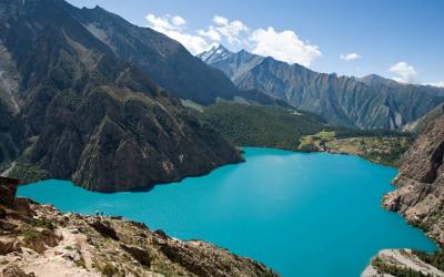
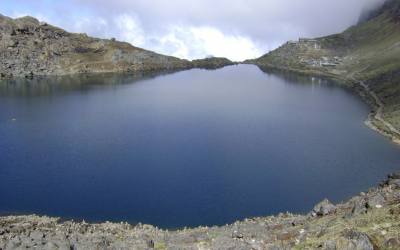
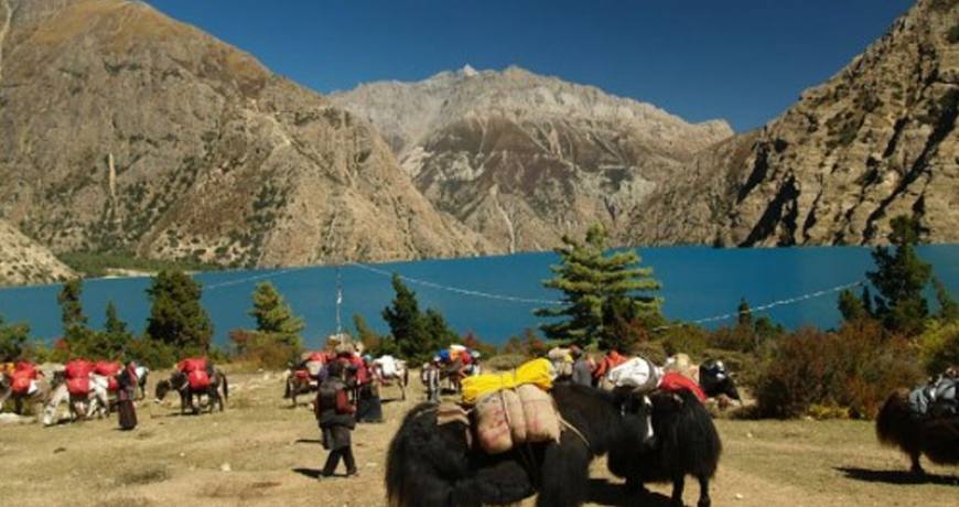
Ringmo lies at the shore of Phoksundo Lake. This lake is of a beauty beyond compare. It has an enchanting deep blue color and is emerald green close to the shore. The water is crystal clear, with not any marine life in it. Steep bold rocks and snowcapped mountains surround the lake. The colors change a bit during the day; you just won’t get enough looking at it. At the shore of the lake, there is a beautiful campsite.
There is a beautiful Bonpo Gompa (Monastery) at the shore of the lake, which is worth a visit. It’s a 20 minute walk to the monastery through the pine forest. In the monastery you can observe a statue of Thönpa Chenrab, the founder of Bonpo religion, a Buddha who lived thousands of years ago.
Day 04: Ringmo/Phoksundo Lake (3733 m), free day
It is indispensable to have an extra day in Ringmo, as your body needs time to acclimatize to the higher altitude. As the Phoksundo Lake is such a beautiful place, it’s a perfect place for a free day.
Day 05: Ringmo/Phoksundo Lake (3733 m) to Chuneba (3639 m) 5 hrs
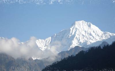
Today you enter the restricted area of Inner Dolpo. You follow the famous Demons Trail from the movie Himalaya (Caravan) of Eric Valli, a beautiful movie about the life of people in Dolpa who bring their yaks over difficult passes bearing salt from Tibet to trade with grain from the lowlands. In the movie, this trail is used during this salt caravan and one of the yaks falls in the lake here. It’s a spectacular trail, going high above the lake . At some parts it gets very narrow due to landslides. The trail climbs to a ridge, from which you have a spectacular view on the lake, Ringmo, the dark green pine forests and the snowcapped mountain Norbung Kang (6085 m) to the south. It’s now a gradual descend to the lake northern shore, which is a good place for lunch. After this the trail climbs through a wide valley, crossing some streams. You have a splendid and nearby view to the flanks and tops of the snowcapped Kanjirowa Himal (6612 m).You arrive at an alpine area with pine trees (junipers), which is a good place to camp.
Day 06: Lakeside camp (3639 m) to Snowfields Camp (4400 m) 7 hrs
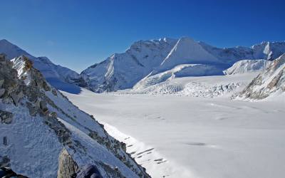
The Phoksundo Valley gets quite narrow, with high rock walls on both sides. You have to cross a couple of streams. After about half an hour, you leave the main valley and enter a narrow gorge. It’s a long, pretty steep climb through the steep sided valley. The campsite is at Snowfields Camp, a name given by Peter Mathiesson in his famous book the Snowleopard. It’s at the foot of the pass that will bring you in the heart of Inner Dolpo tomorrow.
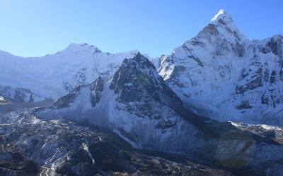
Day 07: Snowfields Camp (4400 m) to Shey Gompa (4310 m) via Kang La (5375 m) 6 hrs
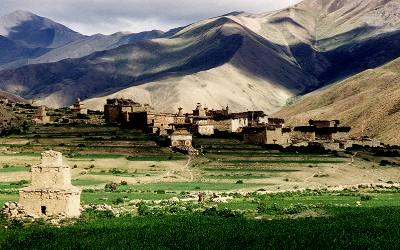
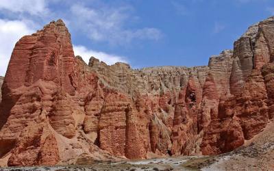
It’s a long and strenuous climb of about 2½ hours over a dusty path to Kang La (5350 m), locally also called Ngadra La. Prayer flags and cairns mark the pass. At the north side of the pass, there is snow most of the times, which makes the descend a bit difficult. The descend is pretty steep the first 45 minutes, but after this, it is going gradually for about 3 hours, till you reach Shey Gompa. Getting nearer, you pass red and white chörtens and mani walls. Shey Gompa is a very small village, with a couple of houses, and of course the gompa (monastery). The 11th century gompa is located beneath the Crystal Peak on a small grassy plain, at the confluence of two rivers. It is said to be constructed by a Tibetan Buddhist, who arrived here on the back of a flying snowlion. It’s a magical place, and Shey Gompa is often called the spiritual heart of Dolpa. Every year hundreds of pilgrims come to visit the gompa and to make a kora (clockwise circuit) of the Crystal Peak. People living here are direct descendents of Tibetans, which you can notice easily by their faces and their dress. They women wear dark dresses with colorful aprons made from yak wool. Men wear a long coat, from which they let one sleeve hanging down.
Day 08: Restday Shey Gompa (4350 m)
During this day, you can go to Tsakang Gompa (4575 m), a monastery from the Buddhist Kagyupa sect. This gompa appears in the movie Himalaya. It is spectacularly located high on a red rocky slope. The trail to Tsakang Gompa partly follows partly the same trail as pilgrims follow to make a kora of the Crystal Peak.
You will probably see flocks of bluesheep in these areas. Many bluesheep live here, as the abbot of Shey gompa imposed a ban on hunting them. Besides, in these regions you have the best chance of seeing the snowleopard.
Day 09: Shey Gompa (4350 m) to Namgung (4430 m) via Shey La (5000 m) 6 hrs
Another pass to cross today, the Shey La, also called Gelu La, of 5000 m. The climb to the pass goes through a narrow valley. From the pass you have a good view to the north of the arid Tibetan Plateau, which is stretching out seemingly endlessly before you. To the east you can see Mustang. After the pass, it’s a long descend to the pastures of Namgung. Scattered in the landscape, you will see some fields. Many times accompanied with a big Tibetan tent, as the fields are too far from the village to go there and go back each day. The people in Namgung are very friendly and open.
Day 10: Namgung (4400 m) to Saldang (4060 m) 3 hrs
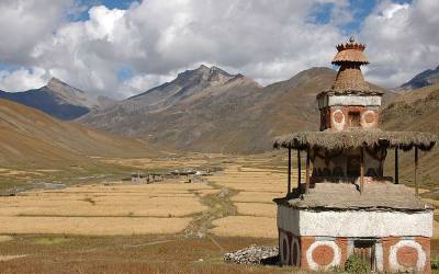
It’s a short hiking day today. The path goes high above the Namgung Khola (River) and then descends steeply to the village of Saldang. Saldang is the largest settlement of Inner-Dolpo. It’s a spread out, traditional agricultural village, surrounded by fields. Barley, buckwheat and potatoes are among the few crops that can grow in this barren landscape. Besides, people live from what the yak gives them (cheese, meat, wool) and from trade. Saldang is close to the Tibetan border and some of the salt trade caravans pass through Saldang. The trading of salt for grain and rice is a century old tradition that still prevails in Inner-Dolpo. The people from Saldang are semi-nomadic. In the warm months they trek in the highlands with their herds of yaks and sheep. The ones who are better off let the pure nomadic people of Dolpa, the Drok-pa, do this work. Sometimes you can see a camp of the Drok-pa in these areas.
Day 11: Saldang (4060 m) to Sibu (4200 m) 5 hrs
It’s a fairly easy walk to Sibu, following the Namgung Khola southwards and passing little villages, like Namdo along the way. The villages are surrounded by terraced fields of barley. The path goes alongside many mani walls, chörtens and some gompa’s, which makes you realize how important Buddhism is for the people of Inner Dolpo. Buddhism is interwoven in each and every aspect of people’s life here.
Day 12: Sibu (4200 m) to Lagmo Che (4570 m) 4 hrs
The trail starts with an easy stretch, following the river. The last village you pass is Raka. After this, you enter a large, inhabited valley. Look out for bluesheep here. Besides, you may even come across a snowleopard... After 2 hours of trekking, the path turns away from the river and climbs steeply to a meadow of about 4570 m, which is often used by yaks to graze. This is Lagmo Che, the base camp for climbing to the Jeng La.
Day 13: Lagmo Che (4570 m) to Tokyu (4209 m) via Jeng La (5110 m) 7 hrs
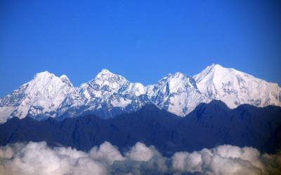
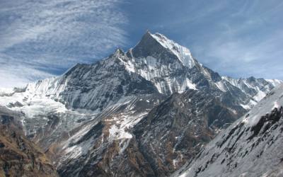
It’s a steep climb of about 2 hours to reach the next pass: Jeng La at 5110 m. From the pass you have a spectacular view to the Dhaulagiri (8167 m). After the pass you descend into the Tarap Valley. You arrive at the village Tokyu (4209), a spread out village, which is the first human settlement after Raka. Tokyu is said to be the highest permanent settlement in the world. The gompa is worth a visit. It has a beautiful statue of Maitreya, the Future Buddha.
Day 14: Tokyu (4209 m) to Dho Tarap ( 4080 m) 2 hrs
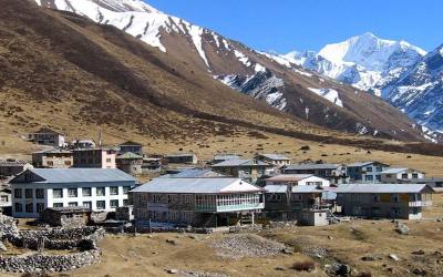
It’s not far to Dho Tarap. On the way, you pass the Cristal Mountain School, which is educating children from Dho and surroundings. It is a nice school, sponsored by a French NGO. If you want, you can visit the school, the teachers are very pleased to show you around. The school has a telephone, the only telephone in Dho and surroundings (019-550522). From the school, it’s about half an hour to Dho. At the entrance you pass nice a gate chörten. Also the people of Dho are direct descendents of Tibetans. Besides the typical dark dresses with colorful aprons, most Dho women wear bracelets of big shells and some have beautiful silver and turquoise headgear. Most men have long hair, with a red ribbon in their hair, in the style of Tibetan Khampas. Besides they wear the long coat, from which one sleeve is hanging down. Dho Tarap is a traditional agricultural village, surrounded by fields. Yaks are used to plough the land. As in the other villages you came across, barley, buckwheat and potatoes are among the few crops that can grow here. But nowadays, small greenhouses enable the people to grow some green vegetables as well. Besides, people live from what the yak gives them and from trade. The houses are made of stones found in the river valley and are in typical Tibetan style, with small windows and the flat roofs stocked with firewood. The people in Dho are very friendly. A Tashi Delek (good day, like the Nepali Namasté), is always welcomed with a big smile.
Close to Dho are 2 monasteries which are worth a visit. Ribo Bhumpa Gompa, right on the hill behind Dho, and Shipchaur Gompa, which is in the village Shipchok, 30 minutes walking from Dho.
Ribo Bhumpa Gompa belongs to Nyingmapa Buddhism, by the local people called Chöba Buddhism. Inside you find a beautiful big statue of Guru Rinpoche. Guru Rinpoche (Padmasambhava) is a very important Buddhist saint from the 7th century AD. He conquered the demons who were preventing Buddhism to get hold in Tibet and in this way made sure that Buddhism could be introduced in Tibet. You can easily recognize him, by his big eyes, little mustache and the staff with skulls he holds. Next to the gompa is a chörten with a chörten inside, which is said to hold the remains of a demon killed by Guru Rinpoche.
Shipchaur Gompa in Shipchok belongs to Bonpo Buddhism. Unfortunately Shipchaur Gompa is in a very bad shape, and very much in need of restoration.
Dho has a big campsite close to the river, and 2 guesthouses where you can stay as well, Angad’s Gallery and Café and one without a name, but with a sign "hotel & shop". In Angad’s Gallery and Café you can find beautiful pictures from daily life in Dho.
Day 15: Dho Tarap (4080 m) to Sisaul (3750 m) 4 hrs
A short day today again, so that you have all the time to explore Dho in the morning.
Leaving Dho Tarap, you come along many mani walls and small chörtens. The path is going down, following the Tarap Khola. Gradually you can see the landscape changing. Some bushes are appearing, it’s getting a bit greener. Just before arriving at Sisaul, you have to climb to a small pass. After the pass, the valley gets suddenly narrow. It’s a short descend to Sisaul, which has a good campsite next to a tent-hotel (this one doesn’t always sell food). You can choose to camp here, or on one of the spots a bit further down.
Day 16: Sisaul (3750 m) to Laina Odar (3370 m) 7-8 hrs
Soon after leaving Sisaul, you climb to a small pass with a nice chörten. After the pass you will see the first trees again. You mostly walk in the river valley with high rocks towering above you on both sides. The landscape is still pretty barren and this is your last change to see the bluesheep or snowleopard…
It’s a fairly easy walk of about 3 to 3½ hours from Sisaul to Nawarpani. The path gradually goes down, with some parts going up as well. At some parts the path is beautifully carved out of the rock, so that you are walking in a kind of three sided tunnel. In Nawarpani (3475 m) you find another tent-hotel, which could be a nice stop for lunch.
After Nawarpani, the landscape gets quickly greener and the path is sometimes going through pine forests, with a wonderful smell. It’s a fairly easy walk over a pretty large path. The path sometimes goes very high above the river. The path goes along the east and west side of the river, crossing the river twice by suspension bridges. In Laina Odar there is another tent-hotel, located at the riverside. This is a good place to camp.
Day 17: Laina Odar (3370 m) to Lingdo (2391 m) 5 hrs
From Laina Odar the trail goes down pretty steep to Laisicap (2772 m). Although the trail is generally in good condition, there are a couple of landslide areas where the trail gets very narrow, and where passing is a bit difficult. The landscape is very beautiful. The path goes partly through forests and you are surrounded by steep cliffs full of pine trees, mostly spruce, fir, juniper and cypress, some of which are huge. Sometimes the river is far below you. The walk to Laisicap takes about 3 hours. There is a tent-hotel, where you could stop for a dahl bath or noodlesoup. At Laisicap you have reached the river again, which is called Thuli Bheri river now. You cross it over a large suspension bridge of 120 meter, high above the river. There is a police checkpost at the other side of the bridge and you have to register and show your permit.
The trail goes down pretty steep for about 45 minutes. After this, it’s a fairly easy walk, gradually going down, with some flat parts as well. The landscape is very green. The sharp rocks are dotted with pine trees, among which junipers. If you are lucky, you can see groups of large grey monkeys here. Behind you, you can see the beautiful snowcapped Kang Tokal (6294 m).
Getting closer to Lingdo, you can see some other villages in the distance, like Sarakot, which is situated high on a cliff. These are the first villages you see after Dho Tarap. You pass some mani walls and chörtens. Lingdo is a small village with one guesthouse with a campingsite. Plus a checkpost, so have your permit at hand again. The people who live in this region are Tarali’s, a Magar group (who are Buddhist as well).
Day 18: Lingdo (2391 m) to Dunai (2140 m) 5 hrs
It’s an easy walk today. The first part goes through rough landscape. The path is sometimes carved out of the rocks, and at a few points very narrow. There are plans to make a motor able road all the way to Dho Tarap. Walking here, it seems that this is really a big challenge, and it surely will take a couple of years; lot’s has to be done to achieve this. But, may be a reason not to wait too long if you want to visit Dolpa…
After 2 ½ hours your reach the small village of Byasgar (2427 m) which has a small local restaurant, serving dahl bath. After Byasgar, the trail goes through a greener landscape again, which sometimes reminds to the European Alps. Rocky slopes are dotted with pine trees, mostly blue pine. At the horizon you see the snowcapped Kang Tokal (6294 m). The path goes slightly up and down, following the Thuli Bheri River, once and a while passing a couple of houses.
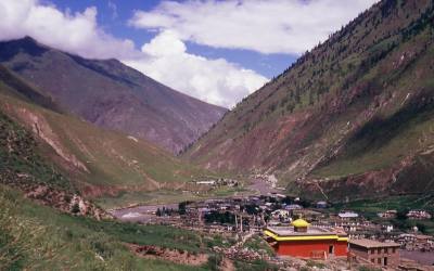
Dunai is the headquarters of Dolpa District. It’s a large village, of about 2.500 people, more or less half Hindu and half Buddhist. Up the hill, there is a Buddhist monastery, which is worth a visit.
Day 19: Dunai (2140 m) to Juphal (2475 m) 3½ hrs
It’s an short walk to Juphal. After 45 minutes you reach a beautiful gate chörten (stupa), which is the entrance to the VDC (Village Development Committee) Dunai. Inside the chörten you can observe some beautiful Buddhist paintings of important Buddhist figures and mandala’s.
You pass the big iron suspension bridge, which you crossed on the first day to get into the Shey Phoksundo National Park. It ’s about 2½ - 3 hours to Juphal from the bridge. The first part goes over a large path. After 45 minutes, you pass through the small village Kalagaonda. About 45 minutes later, you leave the main road and walk over a small path, through fields of barley and wheat, with walnut, peach and apricot trees. It’s a pretty steep climb of about 1 - 1½ hour to reach Juphal. Just before arriving, you pass the Hindu village Dangiwada. Juphal is a large village with a small bazaar where it is nice to look around.
Day 20: Flight Juphal-Nepalgunj-Kathmandu
Early in the morning you fly to Nepalgunj. Especially the first part of the flight through the mountain valleys is spectacular. Later in the day, you fly back to Kathmandu.